Abdón Castro Tolay
| Abdón Castro Tolay | |
|---|---|
| Rural municipality and village | |
.png) | |
| Country |
|
| Province | Jujuy Province |
| Department | Cochinoca |
| Established | 1919 |
| Government | |
| • Village President | Asiscio Puca |
| Population | |
| • Total | 229 |
| Population | |
| Postcode | Y4641 |
| Area code(s) | 03887 |
| Climate | BWk |
Abdón Castro Tolay is a rural municipality and village in the Cochinoca department in Jujuy Province in Argentina.[1] It was founded in October 1919. Its main activity is the raising of llamas and sheep.
Features
Abdón Castro Tolay, formerly Barrancas, is a place of enormous natural walls that preserve cave paintings and petroglyphs. The town, which bears the name of a teacher who dedicated his life to the community, is on provincial route RP 75. The main activity of the town is the breeding of sheep and llamas. There is a garment making spinning mill and regional products, which have revived the previously paralyzed economy. Before, a cooperative of artisans provided blankets to schools in la Puna, a project which sees the active participation of families from other Jujuy towns.
There is a primary school, Secondary School No. 13, a First Aid Center, a public library and a Sportscenter, the Neighborhood Center is named Sargento Cabral, the town square is named 9 de Julio and the cultural sports club is called la Inca. As for religious activity, there is an evangelical and a Catholic church.
Demography
- Population in 1991: 199 inhabitants (INDEC).
- Population in 2001: 229 inhabitants (INDEC), of which 51.10% are women and 48.90% are men.
- Population in 2011: 250 inhabitants approximately. According to the La Hora newspaper of Jujuy.
Photo gallery
-
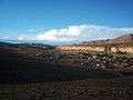
View of the Village of Abdón Castro Tolay
-
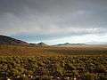
View of the nearby countryside landscape near the village of Abdón Castro Tolay
-
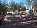
Barrancas Central Plaza
-
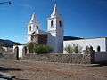
Front of the Church in Barrancas
-
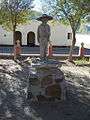
Statue in Barrancas square
-
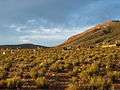
Countryside near to the village of Barrancas
References
- ↑ Ministerio del Interior (Spanish)
Coordinates: 23°22′S 66°04′W / 23.367°S 66.067°W