Aberdeen Parish, New Brunswick
| Aberdeen | |
|---|---|
| Parish | |
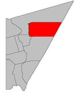 Location within Carleton County, New Brunswick | |
| Coordinates: 46°32′N 67°20′W / 46.53°N 67.34°WCoordinates: 46°32′N 67°20′W / 46.53°N 67.34°W | |
| Country |
|
| Province |
|
| County | Carleton |
| Established | 1863 |
| Area[1] | |
| • Land | 447.91 km2 (172.94 sq mi) |
| Population (2011)[1] | |
| • Total | 981 |
| • Density | 2.2/km2 (6/sq mi) |
| • Pop 2006-2011 |
|
| • Dwellings | 470 |
| Time zone | AST (UTC-4) |
| • Summer (DST) | ADT (UTC-3) |
Aberdeen is a parish in Carleton County, New Brunswick, Canada.[2] Its population in the 2011 Census was 981.
Delineation
Aberdeen Parish is defined in the Territorial Division Act[3] as:
- Beginning at the northwestern angle of lot number ten, granted to William Woodforde, on the Cold Stream; thence running by the magnet of the year one thousand eight hundred and fifty-seven north seventy-two degrees west eight chains to the eastern line of a reserved road, thence following the several courses of the said road by the base line of the lots in a northerly direction to the northwest angle of the lot letter “I”, granted to William Bain; thence south seventy-two degrees and thirty minutes east by the magnet of the year one thousand eight hundred and sixty-one, to meet the eastern line of a reserved road; thence northerly along said road to the northwest angle of lot number fifty-five, in range 5, Johnville [Settlement]; thence easterly to the southeast angle of lot number fifty-six, on said range 5 of Johnville; thence easterly in a direct line to the northwest angle of lot number eighty, in block 2, Glassville [Settlement]; thence easterly along the northern line of said lot and its eastern prolongation to the County line; thence along the said County line in a southwesterly direction to meet the eastern prolongation of the north line of the said grant to William Woodforde; thence along the said prolongation and line westerly to the place of beginning.
Communities
Parish population total does not include incorporated municipalities (in bold):
|
|
|
Demographics
| Visible minorities and Aboriginal population | |||
|---|---|---|---|
| Canada 2006 Census | Population | % of Total Population | |
| Visible minority group Source: [4] | South Asian | 0 | 0 |
| Chinese | 0 | 0 | |
| Black | 0 | 0 | |
| Filipino | 0 | 0 | |
| Latin American | 0 | 0 | |
| Southeast Asian | 0 | 0 | |
| Arab | 0 | 0 | |
| West Asian | 0 | 0 | |
| Korean | 0 | 0 | |
| Japanese | 0 | 0 | |
| Mixed visible minority | 0 | 0 | |
| Other visible minority | 0 | 0 | |
| Total visible minority population | 0 | 0 | |
| Aboriginal group Source: [4] | First Nations | 10 | 1 |
| Métis | 0 | 0 | |
| Inuit | 0 | 0 | |
| Total Aboriginal population | 10 | 1 | |
| White | 950 | 99 | |
| Total population | 960 | 100 | |
PopulationPopulation trend[5]
|
LanguageMother tongue language (2006)[6]
|
See also
References
- 1 2 2011 Statistics Canada Census Profile: Aberdeen Parish, New Brunswick
- ↑ New Brunswick Provincial Archives - Aberdeen Parish
- ↑ "Territorial Division Act (R.S.N.B. 1973, c. T-3)". Government of New Brunswick website. Retrieved 17 August 2016.
- 1 2 Community Profiles from the 2006 Census, Statistics Canada - Census Subdivision
- ↑ Statistics Canada: 1951, 1996, 2001, 2006, 2011 census
- ↑ 2006 Statistics Canada Community Profile: Aberdeen Parish, New Brunswick
 |
Kent Parish | | ||
| |
Douglas Parish (York County) | |||
| ||||
| | ||||
| Peel Parish | Brighton Parish |
| Subdivisions | |
|---|---|
| Cities | |
| Counties | |
| |
This article is issued from Wikipedia - version of the 8/17/2016. The text is available under the Creative Commons Attribution/Share Alike but additional terms may apply for the media files.