Ain el-Ghouaybeh
| Ain el-Ghoubayeh عين الغويبة Ayn al-Ghubayah | |
|---|---|
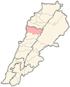
 Ain el-Ghoubayeh Location in Lebanon | |
| Coordinates: 34°4′52″N 35°51′29″E / 34.08111°N 35.85806°ECoordinates: 34°4′52″N 35°51′29″E / 34.08111°N 35.85806°E | |
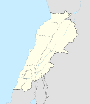
| Country | Lebanon |
| Governorate | Mount Lebanon |
| District | Jbeil |
| Area | |
| • Total | 64 ha (158 acres) |
| Elevation | 800 m (2,600 ft) |
Ain el-Ghoubayeh (Arabic: عين الغويبة, also spelled Ayn al-Ghubayah) is a mountainous village in the Jbeil District of Mount Lebanon Governorate, Lebanon. It is 82 kilometers north of Beirut. Ain el-Ghoubayeh has an average elevation of 800 meters above sea level and a total land area of 64 hectares.[1] Its inhabitants are predominantly Shia Muslims.[2]
References
- ↑ "Ain El Ghoubayeh (Jbayl)". Localiban. Localiban. 2008-01-16. Retrieved 2016-02-12.
- ↑ "Elections municipales et ikhtiariah au Mont-Liban" (pdf). Localiban. Localiban. 2010. p. 19. Retrieved 2016-02-12.
Capital: Jbeil | ||
| Towns and villages |
|  |
| Landmarks |
| |
This article is issued from Wikipedia - version of the 2/12/2016. The text is available under the Creative Commons Attribution/Share Alike but additional terms may apply for the media files.