List of airports in Antigua and Barbuda
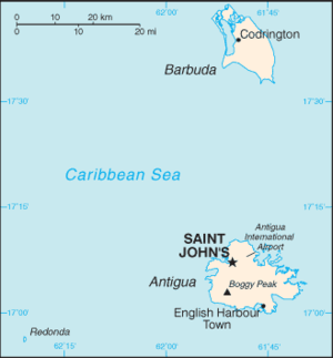
Map of Antigua and Barbuda
There are three airports operating in Antigua and Barbuda, a nation lying between the Caribbean Sea and the Atlantic Ocean. Antigua and Barbuda consists of two major inhabited islands, Antigua and Barbuda, and a number of smaller islands (including Great Bird, Green, Guinea, Long, Maiden and York Islands). Separated by a few nautical miles, the group is in the middle of the Leeward Islands, part of the Lesser Antilles.
Airports
Boldface indicates the airport has scheduled passenger service on commercial airlines.
| City served | Island | ICAO | IATA | Airport name | Coordinates |
|---|---|---|---|---|---|
| St. John's | Antigua | TAPA | ANU | V. C. Bird International Airport | 17°08′12″N 61°47′34″W / 17.13667°N 61.79278°W |
| Codrington | Barbuda | TAPH | BBQ | Barbuda Codrington Airport | 17°38′09″N 61°49′43″W / 17.63583°N 61.82861°W |
| Coco Point | Barbuda | TAPT | Coco Point Lodge Airstrip (private) | 17°33′20″N 61°45′55″W / 17.55556°N 61.76528°W |
See also
- Transport in Antigua and Barbuda
- List of airports by ICAO code: T#TA - Antigua and Barbuda
- Wikipedia: WikiProject Aviation/Airline destination lists: North America#Antigua and Barbuda
References
- "ICAO Location Indicators by State" (PDF). International Civil Aviation Organization. 17 September 2010.
- "UN Location Codes: Antigua and Barbuda". UN/LOCODE 2011-2. UNECE. 28 February 2012. – includes IATA codes
- Great Circle Mapper: Antigua and Barbuda – IATA codes, ICAO codes and coordinates
This article is issued from Wikipedia - version of the 6/3/2016. The text is available under the Creative Commons Attribution/Share Alike but additional terms may apply for the media files.