Akuna Bay, New South Wales
This article is about the urban locality. For the bay that provides the locality with its name, see Akuna Bay.
| Akuna Bay Sydney, New South Wales | |||||||||||||
|---|---|---|---|---|---|---|---|---|---|---|---|---|---|
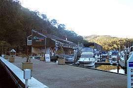 Boats moored at Akuna Bay Marina | |||||||||||||
| Postcode(s) | 2084 | ||||||||||||
| Location | 38 km (24 mi) north of Sydney CBD | ||||||||||||
| LGA(s) | Northern Beaches Council | ||||||||||||
| State electorate(s) | Pittwater | ||||||||||||
| Federal Division(s) | Mackellar | ||||||||||||
| |||||||||||||
Akuna Bay is an urban place[1] in Sydney, Australia. Akuna Bay is located 38 kilometres (24 mi) north of the Sydney central business district, in the local government area of Northern Beaches Council.
Akuna Bay sits in the Kuring-gai Chase National Park[2] and takes its name[3] from the bay on Coal and Candle Creek. It can be accessed by a marina on the bay or by Liberator General San Martin Drive.
History
Akuna was thought to be an Aboriginal word meaning to follow.[1] It actually is a mangled version of the Dieri word ngaka-rna meaning "to flow".[4]
References
- 1 2 "Akuna Bay (urban place)". Geographical Names Register (GNR) of NSW. Geographical Names Board of New South Wales.
- ↑ Akuna Bay (Map). National Parks & Wildlife Service. 2014. Retrieved 11 June 2014.
- ↑ "Akuna Bay (bay)". Geographical Names Register (GNR) of NSW. Geographical Names Board of New South Wales.
- ↑
Coordinates: 33°38′53″S 151°14′06″E / 33.648°S 151.235°E
This article is issued from Wikipedia - version of the 9/22/2016. The text is available under the Creative Commons Attribution/Share Alike but additional terms may apply for the media files.