Alcorisa
| Alcorisa | |||
|---|---|---|---|
| |||
 Alcorisa | |||
| Coordinates: 40°53′N 0°23′W / 40.883°N 0.383°WCoordinates: 40°53′N 0°23′W / 40.883°N 0.383°W | |||
| Country | Spain | ||
| Autonomous community | Aragon | ||
| Province | Teruel | ||
| Comarca | Bajo Aragón | ||
| Area | |||
| • Total | 121.20 km2 (46.80 sq mi) | ||
| Elevation | 632 m (2,073 ft) | ||
| Population (2004) | |||
| • Total | 3,495 | ||
| • Density | 29.1/km2 (75/sq mi) | ||
| Demonym(s) | Alcorisano, Alcorisana | ||
| Time zone | CET (UTC+1) | ||
| • Summer (DST) | CEST (UTC+2) | ||
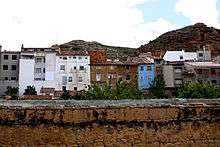
View of Alcorisa

Drama de la Cruz, Monte Calvario, Alcorisa. Part of Ruta del Tambor y el Bombo
Alcorisa is a municipality in the province of Teruel, Aragon, Spain. According to the 2010 census[1] the municipality has a population of 3,642 inhabitants.
Alcorisa is located right by the N-211 road, 13 km to the SW of Calanda. This town is part of the Ruta del Tambor y del Bombo.
See also
References
External links
| Wikimedia Commons has media related to Alcorisa. |
This article is issued from Wikipedia - version of the 5/19/2016. The text is available under the Creative Commons Attribution/Share Alike but additional terms may apply for the media files.