Allardville Parish, New Brunswick
| Allardville | |
|---|---|
| Parish | |
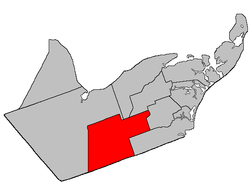 Location within Gloucester County, New Brunswick | |
| Coordinates: 47°29′N 65°30′W / 47.48°N 65.5°W | |
| Country |
|
| Province |
|
| County | Gloucester |
| Established | 1946 |
| Area[1] | |
| • Land | 655.21 km2 (252.98 sq mi) |
| Population (2011)[1] | |
| • Total | 2,081 |
| • Density | 3.2/km2 (8/sq mi) |
| • Pop 2006-2011 |
|
| • Dwellings | 909 |
| Time zone | AST (UTC-4) |
| • Summer (DST) | ADT (UTC-3) |
Allardville is a Canadian parish in Gloucester County, New Brunswick.[2]
Delineation
Allardville Parish is defined in the Territorial Division Act[3] as:
- Beginning at a point in the Canadian National Railways where the same is intersected by the western prolongation of the south limit of lots lettered A and B, granted to John Porter, and situated on both sides of the Highway 8;[lower-alpha 1] thence in an easterly direction along said prolongation, said limit of said lots and the eastern prolongation of same to a point in the west limit of a seven thousand seven hundred and fifty acre tract, granted to Henry H. Swinny; thence in a southerly direction along said limit of said tract and the southern prolongation of same to a point in the north limit of Tier One North, Allardville East [Settlement]; thence in an easterly direction along said limit of Allardville East; and the eastern prolongation of same to a point in the west limit of lot number two hundred and sixteen, Range Two, Saint-Isidore [Settlement]; thence in a southerly direction along said limit of said lot in Ranges Two, Three and Four of Saint-Isidore, to a point in the division line between said Range Four and Range Five of Saint-Isidore; thence in a westerly direction along said division line to the northwest angle of lot number two hundred and twenty-five in said Range Five of Saint-Isidore; thence in a southerly direction along the west limit of said lot and the southern prolongation of same to a point in the western prolongation of the south limit of Range Nine, Saint-Isidore; thence in a westerly direction along said prolongation of said limit of said Range to a point in the division line between Timber Blocks Numbers Three and Four, Range Eight; thence in a southerly direction along said division line of said Blocks in Ranges Eight, Nine and Ten to a point in the Gloucester-Northumberland County line; thence in a westerly direction along said County line to a point in the Canadian National Railway; and thence in a northerly direction along said railway to the point of beginning.
Communities
Parish population total does not include incorporated municipalities (in bold) and communities within their respective boundaries (in italics).
|
|
Demographics
Population
| Canada census – Allardville Parish, New Brunswick community profile | |||
|---|---|---|---|
| 2011 | 2006 | 2001 | |
| Population: | 2,081 (-3.3% from 2006) | 2,151 (-12.2% from 2001) | 2,450 (-10.6% from 1996) |
| Land area: | 655.21 km2 (252.98 sq mi) | 655.11 km2 (252.94 sq mi) | 655.12 km2 (252.94 sq mi) |
| Population density: | 3.2/km2 (8.3/sq mi) | 3.3/km2 (8.5/sq mi) | 3.7/km2 (9.6/sq mi) |
| Median age: | 47.0 (M: 46.3, F: 48.0) | 42.9 (M: 42.3, F: 44.0) | 39.2 (M: 38.8, F: 39.6) |
| Total private dwellings: | 909 | 890 | 934 |
| Median household income: | $43,501 | $38,572 | $29,869 |
| References: 2011[4] 2006[5] 2001[6] | |||
| Historical Census Data - Allardville Parish, New Brunswick[7] | ||||||||||||||||||||||||||
|---|---|---|---|---|---|---|---|---|---|---|---|---|---|---|---|---|---|---|---|---|---|---|---|---|---|---|
|
|
| ||||||||||||||||||||||||
Language
| Canada Census Mother Tongue - Allardville Parish, New Brunswick[7] | ||||||||||||||||||
|---|---|---|---|---|---|---|---|---|---|---|---|---|---|---|---|---|---|---|
| Census | Total | French |
English |
French & English |
Other | |||||||||||||
| Year | Responses | Count | Trend | Pop % | Count | Trend | Pop % | Count | Trend | Pop % | Count | Trend | Pop % | |||||
| 2011 |
2,060 |
1,970 | |
95.63% | 65 | |
3.16% | 25 | |
1.21% | 0 | |
0.00% | |||||
| 2006 |
2,135 |
2,030 | |
95.08% | 65 | |
3.04% | 0 | |
0.00% | 40 | |
1.87% | |||||
| 2001 |
2,440 |
2,305 | |
94.47% | 120 | |
4.92% | 15 | |
0.61% | 0 | |
0.00% | |||||
| 1996 |
2,750 |
2,620 | n/a | 95.27% | 120 | n/a | 4.36% | 10 | n/a | 0.36% | 0 | n/a | 0.00% | |||||
See also
Footnotes
References
- 1 2 2011 Statistics Canada Census Profile: Allardville Parish, New Brunswick
- ↑ New Brunswick Provincial Archives - Allardville Parish
- ↑ "Territorial Division Act (R.S.N.B. 1973, c. T-3)". Government of New Brunswick website. Retrieved 17 August 2016.
- ↑ "2011 Community Profiles". Canada 2011 Census. Statistics Canada. July 5, 2013. Retrieved 2014-04-06.
- ↑ "2006 Community Profiles". Canada 2006 Census. Statistics Canada. March 30, 2011. Retrieved 2014-04-06.
- ↑ "2001 Community Profiles". Canada 2001 Census. Statistics Canada. February 17, 2012. Retrieved 2014-04-06.
- 1 2 Statistics Canada: 1996, 2001, 2006, 2011 census

| Subdivisions | |
|---|---|
| Cities | |
| Counties | |
| |
Coordinates: 47°28′48″N 65°30′00″W / 47.48000°N 65.50000°W
This article is issued from Wikipedia - version of the 9/9/2016. The text is available under the Creative Commons Attribution/Share Alike but additional terms may apply for the media files.