Aloran, Misamis Occidental
| Aloran | |
|---|---|
| Municipality | |
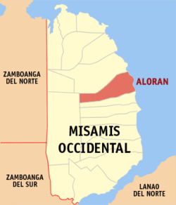 Map of Misamis Occidental with Aloran highlighted | |
.svg.png) Aloran Location within the Philippines | |
| Coordinates: 08°25′N 123°49′E / 8.417°N 123.817°ECoordinates: 08°25′N 123°49′E / 8.417°N 123.817°E | |
| Country | Philippines |
| Region | Northern Mindanao (Region X) |
| Province | Misamis Occidental |
| District | 1st district of Misamis Occidental |
| Founded | January 1, 1917 |
| Barangays | 38 |
| Government[1] | |
| • Mayor | Jimmy R. Regalado |
| Area[2] | |
| • Total | 118.06 km2 (45.58 sq mi) |
| Population (2010)[3] | |
| • Total | 26,630 |
| • Density | 230/km2 (580/sq mi) |
| Time zone | PST (UTC+8) |
| ZIP code | 7206 |
| Dialing code | +63 (0)88 |
| Income class | 4th |
Aloran is a fourth class municipality in the province of Misamis Occidental, Philippines. According to the 2010 census, it has a population of 26,630 people.[3]
Barangay
Aloran is politically subdivided into 38 barangays.[2]
- Balintonga
- Banisilon
- Burgos
- Calube
- Caputol
- Casusan
- Conat
- Culpan
- Dalisay
- Dullan,
- Ibabao
- Tubod
- Labo
- Lawa-an
- Lobogon
- Lumbayao
- Makawa
- Manamong
- Matipaz
- Maular
- Mitazan
- Mohon
- Monterico
- Nabuna
- Palayan
- Pelong
- Ospital (poblacion)
- Roxas
- San Pedro
- Santa Ana
- Sinampongan
- Taguanao
- Tawi-tawi
- Toril
- Tuburan
- Zamora
- Macubon (Sina-ad)
- Tugaya
Demographics
| Population census of Aloran | ||
|---|---|---|
| Year | Pop. | ±% p.a. |
| 1990 | 20,812 | — |
| 1995 | 22,275 | +1.28% |
| 2000 | 23,127 | +0.81% |
| 2007 | 23,450 | +0.19% |
| 2010 | 26,630 | +4.74% |
| Source: National Statistics Office[3] | ||
Festival
"Bunga Dag Tabinal Festival"
References
- ↑ "Official City/Municipal 2013 Election Results". Intramuros, Manila, Philippines: Commission on Elections (COMELEC). 1 July 2013. Retrieved 5 September 2013.
- 1 2 "Province: MISAMIS OCCIDENTAL". PSGC Interactive. Makati City, Philippines: National Statistical Coordination Board. Retrieved 14 July 2014.
- 1 2 3 "Total Population by Province, City, Municipality and Barangay: as of May 1, 2010" (PDF). 2010 Census of Population and Housing. National Statistics Office. Retrieved 14 July 2014.
External links
- Philippine Standard Geographic Code
- Philippine Census Information
- Local Governance Performance Management System
 |
Oroquieta | | ||
| Don V. Chiongbian | |
Iligan Bay | ||
| ||||
| | ||||
| Panaon |
Oroquieta (capital) | |
| Municipalities | |
| Component cities | |
This article is issued from Wikipedia - version of the 11/1/2016. The text is available under the Creative Commons Attribution/Share Alike but additional terms may apply for the media files.