Altmärkische Höhe
| Altmärkische Höhe | |
|---|---|
 Altmärkische Höhe | |
Location of Altmärkische Höhe within Stendal district 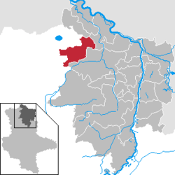 | |
| Coordinates: 52°49′N 11°34′E / 52.817°N 11.567°ECoordinates: 52°49′N 11°34′E / 52.817°N 11.567°E | |
| Country | Germany |
| State | Saxony-Anhalt |
| District | Stendal |
| Municipal assoc. | Seehausen |
| Area | |
| • Total | 98.91 km2 (38.19 sq mi) |
| Population (2015-12-31)[1] | |
| • Total | 1,899 |
| • Density | 19/km2 (50/sq mi) |
| Time zone | CET/CEST (UTC+1/+2) |
| Postal codes | 39606, 39615 |
| Dialling codes | 039386, 039391, 039399 |
| Vehicle registration | SDL |
Altmärkische Höhe is a municipality in the district of Stendal, in Saxony-Anhalt, Germany.
It was formed on 1 January 2010 by the merger of the former municipalities Boock, Bretsch, Gagel, Heiligenfelde, Kossebau, Losse and Lückstedt.
References
- ↑ "Bevölkerung der Gemeinden – Stand: 31.12.2015" (PDF). Statistisches Landesamt Sachsen-Anhalt (in German).
Towns and municipalities in the district of Stendal | ||
|---|---|---|
This article is issued from Wikipedia - version of the 6/20/2015. The text is available under the Creative Commons Attribution/Share Alike but additional terms may apply for the media files.