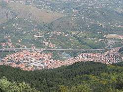
Altofonte
| Altofonte | |
|---|---|
| Comune | |
| Comune di Altofonte | |
 | |
 Altofonte Location of Altofonte in Italy | |
| Coordinates: 38°3′N 13°18′E / 38.050°N 13.300°ECoordinates: 38°3′N 13°18′E / 38.050°N 13.300°E | |
| Country | Italy |
| Region | Sicily |
| Province / Metropolitan city | Palermo (PA) |
| Frazioni | Piano Maglio, Blandino |
| Government | |
| • Mayor | Vincenzo Di Girolamo |
| Area | |
| • Total | 35 km2 (14 sq mi) |
| Elevation | 350 m (1,150 ft) |
| Population (31 December 2013)[1] | |
| • Total | 10,378 |
| • Density | 300/km2 (770/sq mi) |
| Demonym(s) | Altofontini or Parchitani |
| Time zone | CET (UTC+1) |
| • Summer (DST) | CEST (UTC+2) |
| Postal code | 90030 |
| Dialing code | 091 |
| Patron saint | St. Hanna |
| Saint day | 26 July |
| Website | Official website |
Altofonte (Sicilian: Parcu) is a comune (municipality) in the Metropolitan City of Palermo in the Italian region Sicily, located about 9 kilometres (6 mi) southwest of Palermo.
Altofonte borders the following municipalities: Belmonte Mezzagno, Monreale, Palermo, Piana degli Albanesi, San Giuseppe Jato.
Main sights
- Church of Santa Maria in Altofonte, built in 1633.
- Church of San Michele Arcangelo (early 12th century)
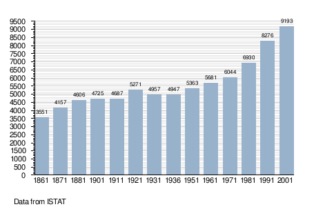
Demographic evolution
References
External links
This article is issued from Wikipedia - version of the 2/8/2016. The text is available under the Creative Commons Attribution/Share Alike but additional terms may apply for the media files.