Annaghmore, County Antrim
This article is about the townland in County Antrim. For other uses, see Annaghmore.
| Annaghmore, County Antrim | |
| Irish: Eanach Mór | |
 Annaghmore, County Antrim |
|
| County | County Antrim |
|---|---|
| Country | Northern Ireland |
| Sovereign state | United Kingdom |
| Postcode district | BT41 |
| Dialling code | 028 |
| EU Parliament | Northern Ireland |
|
|
Coordinates: 54°43′55″N 6°27′36″W / 54.732°N 6.460°W
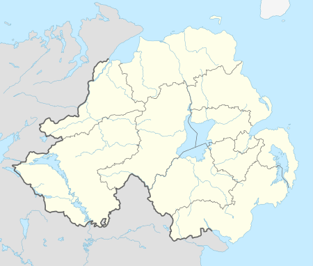
Annaghmore (from Irish: Eanach Mór, meaning "great marsh")[1] is a townland of 220 acres in County Antrim, Northern Ireland. It is situated in the civil parish of Duneane and the historic barony of Toome Upper.[2]
See also
References
- ↑ "Annaghmore". Place Names NI. Retrieved 13 May 2015.
- ↑ "Annaghmore". IreAtlas Townlands Database. Retrieved 13 May 2015.
This article is issued from Wikipedia - version of the 5/22/2015. The text is available under the Creative Commons Attribution/Share Alike but additional terms may apply for the media files.