Arpke
| Arpke | ||
|---|---|---|
| Stadtteil of Lehrte | ||
| ||
 Arpke | ||
| Coordinates: 52°23′16″N 10°05′50″E / 52.38778°N 10.09722°ECoordinates: 52°23′16″N 10°05′50″E / 52.38778°N 10.09722°E | ||
| Country | Germany | |
| State | Lower Saxony | |
| District | Hanover | |
| Town | Lehrte | |
| Government | ||
| • Mayor | Hans-Heinrich Bethmann (CDU) | |
| Area | ||
| • Total | 10.69 km2 (4.13 sq mi) | |
| Population (2009-12-31) | ||
| • Total | 2,962 | |
| • Density | 280/km2 (720/sq mi) | |
| Time zone | CET/CEST (UTC+1/+2) | |
| Postal codes | 31275 | |
| Dialling codes | 05175 | |
| Vehicle registration | H | |

Arpke is a village in the town of Lehrte in the district of Hanover, in Lower Saxony, Germany. It is situated approximately 30 km east of Hanover.
Since 1893 Arpke has a railway station on the Berlin–Lehrte railway and is connected once per hour to Hanover and Wolfsburg.
Literature
- Frank Henschel: Arpke. Chronik eines Dorfes (Stadtgeschichtliche Hefte der Stadt Lehrte, Band 17), Stadt Lehrte (Hg.), 7/2000, 208 Seiten mit Abbildungen, broschiert
- Heimatbund Arpke (Hg.): Arpke. Nicht nur historische Ansichten eines niedersächsischen Dorfes. Festschrift zum 40jährigen Bestehen des Heimatbundes Arpke, 2005, broschiert, 62 Seiten mit Abbildungen in Schwarz-weiß
External links
| Wikimedia Commons has media related to Lehrte. |
-
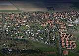
Aerial picture of Arpke facing eastwards
-
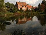
View across the pond in the centre of the village
-
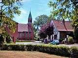
Lutheran church “Holy Cross”, on the lefthand the youth centre
-
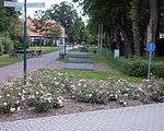
Walkway along the pond
Towns and municipalities in Hanover Region | ||
|---|---|---|
This article is issued from Wikipedia - version of the 4/18/2015. The text is available under the Creative Commons Attribution/Share Alike but additional terms may apply for the media files.