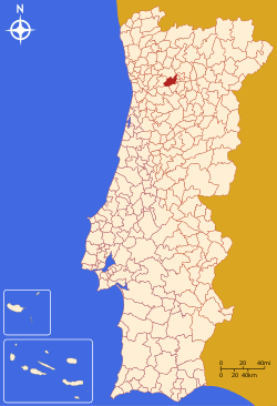
Baião, Portugal
| Baião | |||
|---|---|---|---|
| Municipality | |||
 | |||
| |||
 | |||
| Coordinates: 41°10′N 8°02′W / 41.167°N 8.033°WCoordinates: 41°10′N 8°02′W / 41.167°N 8.033°W | |||
| Country |
| ||
| Region | Norte | ||
| Subregion | Tâmega | ||
| Intermunic. comm. | Tâmega e Sousa | ||
| District | Porto | ||
| Parishes | 14 | ||
| Government | |||
| • President | Paulo Pereira (PS) | ||
| Area | |||
| • Total | 174.53 km2 (67.39 sq mi) | ||
| Population (2011) | |||
| • Total | 20,522 | ||
| • Density | 120/km2 (300/sq mi) | ||
| Time zone | WET/WEST (UTC+0/+1) | ||
| Website | http://www.cm-baião.pt | ||

Baião ([baˈjɐ̃w]) is a municipality in Porto District in Portugal. The population in 2011 was 20,522,[1] in an area of 174.53 km².[2]
The present Mayor is Paulo Pereira, elected from the Socialist Party. The municipal holiday is August 24.
Parishes
Administratively, the municipality is divided into 14 civil parishes (freguesias):[3]
- Ancede e Ribadouro
- Baião (Santa Leocádia) e Mesquinhata
- Campelo e Ovil
- Frende
- Gestaçô
- Gove
- Grilo
- Loivos da Ribeira e Tresouras
- Loivos do Monte
- Santa Cruz do Douro e São Tomé de Covelas
- Santa Marinha do Zêzere
- Teixeira e Teixeiró
- Valadares
- Viariz
References
- ↑ Instituto Nacional de Estatística
- ↑ Direção-Geral do Território
- ↑ Diário da República. "Law nr. 11-A/2013, page 552 21" (pdf) (in Portuguese). Retrieved 17 July 2014.
External links
| Wikimedia Commons has media related to Baião. |
This article is issued from Wikipedia - version of the 10/24/2016. The text is available under the Creative Commons Attribution/Share Alike but additional terms may apply for the media files.