Bilara
| Bilara Bilada | |
|---|---|
| city | |
| Nickname(s): Balipur | |
 Bilara  Bilara Location in Rajasthan, India | |
| Coordinates: 26°10′45″N 73°42′20″E / 26.1792°N 73.7056°ECoordinates: 26°10′45″N 73°42′20″E / 26.1792°N 73.7056°E | |
| Country |
|
| State | Rajasthan |
| District | Jodhpur |
| Tehsil | Bilara |
| Elevation | 269 m (883 ft) |
| Population (2011) | |
| • Total | 71,396 |
| Languages | |
| • Official | Hindi |
| Time zone | IST (UTC+5:30) |
| PIN | 342602 |
Bilara is a city and a municipality located in the Jodhpur district of Rajasthan, India. It is the administrative headquarters for Bilara tehsil and a market center for the surrounding agricultural area.
Demographics
Bilara is a Municipality city in district of Jodhpur, Rajasthan. The Bilara city is divided into 25 wards for which elections are held every 5 years. In the 2011 India census, Urban population of Bilara was 71,396. Males constituted 51.8% (36,974) of the population and females 48.2% (34,422), for a gender ratio of 931 females per thousand males.[1] Bilara had an average literacy rate of 57%, lower than the national average of 59.5%; with male literacy of 73% and female literacy of 40%. In 2001 in Bilara, 13.6% of the population was under 6 years of age.[1]
Infrastructure
Bilara lies on National Highway 112 between the city of Jodhpur and Jaitaran,[2] and is the terminus for a rail line from Pipar City.
Place of Interest
In Bilara town there arr lots of palace of interest . There is a historical Palace, Shri Aai Mata ji Temple , Dada Wadi, Kalpvriksha , Raja Bali Temple , Jaswant Sarar Dam, Monuments of Great Kingh Harshwardhan and many more.
[http://%5B%5BFile:Palace%20of%20Bilara%20View.jpeg|Palace%20of%20Bilara%20View%5D%5D 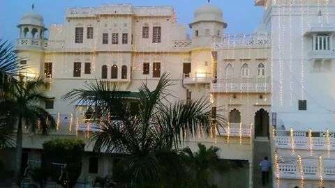
References
- ↑ http://www.censusindia.gov.in/PopulationFinder/Sub_Districts_Master.aspx?state_code=08&district_code=15
- ↑ "Statewise Length of National Highways in India". Ministry of Road Transport and Highways.