Bindawa
| Bindawa | |
|---|---|
| LGA and town | |
 Bindawa Location in Nigeria | |
| Coordinates: 12°43′N 7°50′E / 12.717°N 7.833°ECoordinates: 12°43′N 7°50′E / 12.717°N 7.833°E | |
| Country |
|
| State | Katsina State |
| Established | 1989 |
| Government | |
| • Chairman | Ibrahim Doro |
| Area | |
| • Total | 398 km2 (154 sq mi) |
| Population (2006 census) | |
| • Total | 152,356 |
| Time zone | WAT (UTC+1) |
| 3-digit postal code prefix | 822 |
| ISO 3166 code | NG.KT.BI |
Bindawa is a Local Government Area in Katsina State, Nigeria. Its headquarters are in the town of Bindawa in the west of the area at12°40′11″N 7°48′19″E / 12.66972°N 7.80528°E.
It has an area of 398 km² and a population of 152,356 at the 2006 census.
It is a home to secondary school:
- Government Science Secondary School, Bindawa
The postal code of the area is 822.[1]
References
- ↑ "Post Offices- with map of LGA". NIPOST. Archived from the original on 2009-10-07. Retrieved 2009-10-20.
State capital: Katsina | ||
| LGAs | 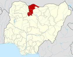 | |
This article is issued from Wikipedia - version of the 11/2/2016. The text is available under the Creative Commons Attribution/Share Alike but additional terms may apply for the media files.