Bischofszell District
| Bischofszell District Bezirk Bischofszell | |
|---|---|
| District | |
 | |
| Country |
|
| Canton |
|
| Capital | Bischofszell |
| Area | |
| • Total | 95.7 km2 (36.9 sq mi) |
| Population (2009) | |
| • Total | 31,773 |
| • Density | 330/km2 (860/sq mi) |
| Time zone | CET (UTC+1) |
| • Summer (DST) | CEST (UTC+2) |
| Municipalities | 8 |
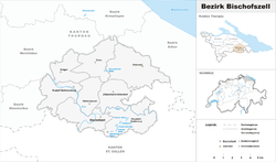
Bischofszell District is a former district of the canton of Thurgau in Switzerland. It had a population of 31,773 (as of 2009).[1] Its capital was the town of Bischofszell.
The district contained the following municipalities:
| Coat of arms | Municipality | Population (31 December 2015)[2] |
Area km²[3] |
|---|---|---|---|
| | Amriswil | 13,113 | 19.02 |
| | Bischofszell | 5,895 | 11.62 |
| | Erlen | 3,624 | 12.19 |
| | Hauptwil-Gottshaus | 1,915 | 12.49 |
| | Hohentannen | 616 | 8.00 |
| | Kradolf-Schönenberg | 3,554 | 10.96 |
| | Sulgen | 3,708 | 9.13 |
| | Zihlschlacht-Sitterdorf | 2,254 | 12.20 |
| Total | 31,773 | 95.7 |
References
- ↑ Swiss Federal Statistical Office - STAT-TAB, online database – Ständige und nichtständige Wohnbevölkerung nach institutionellen Gliederungen, Geburtsort und Staatsangehörigkeit (German) accessed 30 August 2016
- ↑ Swiss Federal Statistical Office - STAT-TAB, online database – Ständige und nichtständige Wohnbevölkerung nach institutionellen Gliederungen, Geburtsort und Staatsangehörigkeit (German) accessed 30 August 2016
- ↑ Swiss Federal Statistical Office-Land Use Statistics 2009 data (German) accessed 25 March 2010
Coordinates: 47°30′N 9°14′E / 47.500°N 9.233°E
This article is issued from Wikipedia - version of the 6/21/2013. The text is available under the Creative Commons Attribution/Share Alike but additional terms may apply for the media files.