Biya River
| Biya River | |
|---|---|
 | |
| Country | Russia |
| Basin | |
| Main source | Teletskoye Lake |
| River mouth | Ob River |
| Basin size | 37,000 km2 (14,000 sq mi) |
| Physical characteristics | |
| Length | 301 km (187 mi) |
| Discharge |
|
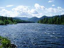
The Biya River (Russian: Бия) is a river in the Altai Republic and Altai Krai in Russia. It forms the Ob River as it joins the Katun River. The Biya River is 301 km long; the area of its drainage basin is 37,000 km2. It flows out of the Teletskoye Lake. The river freezes up during the mid-November to early December (some parts of the river freeze over on a year-to-year basis). It breaks up in the early or mid-April. The Biya River is navigable up to the town of Biysk.
The maximum depth of river is 28 feet (8.5 m).
Coordinates: 51°47′10″N 87°14′46″E / 51.786°N 87.246°E
This article is issued from Wikipedia - version of the 4/22/2016. The text is available under the Creative Commons Attribution/Share Alike but additional terms may apply for the media files.