Bouquet, Gard
| Bouquet | ||
|---|---|---|
|
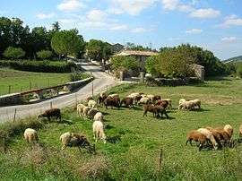
A general view of Bouquet | ||
| ||
 Bouquet | ||
|
Location within Occitanie region  Bouquet | ||
| Coordinates: 44°09′36″N 4°17′27″E / 44.16°N 4.2908°ECoordinates: 44°09′36″N 4°17′27″E / 44.16°N 4.2908°E | ||
| Country | France | |
| Region | Occitanie | |
| Department | Gard | |
| Arrondissement | Alès | |
| Canton | Saint-Ambroix | |
| Intercommunality | Mont Bouquet | |
| Government | ||
| • Mayor (2008–2015) | Henri Pinatel | |
| Area1 | 30.26 km2 (11.68 sq mi) | |
| Population (2008)2 | 190 | |
| • Density | 6.3/km2 (16/sq mi) | |
| Time zone | CET (UTC+1) | |
| • Summer (DST) | CEST (UTC+2) | |
| INSEE/Postal code | 30048 / 30580 | |
| Elevation |
159–600 m (522–1,969 ft) (avg. 631 m or 2,070 ft) | |
|
1 French Land Register data, which excludes lakes, ponds, glaciers > 1 km² (0.386 sq mi or 247 acres) and river estuaries. 2 Population without double counting: residents of multiple communes (e.g., students and military personnel) only counted once. | ||
.svg.png)
Bouquet is a commune in the Gard department in southern France.
Population
| Historical population | ||
|---|---|---|
| Year | Pop. | ±% |
| 1793 | 250 | — |
| 1821 | 294 | +17.6% |
| 1846 | 456 | +55.1% |
| 1872 | 464 | +1.8% |
| 1901 | 318 | −31.5% |
| 1926 | 163 | −48.7% |
| 1946 | 101 | −38.0% |
| 1962 | 76 | −24.8% |
| 1968 | 73 | −3.9% |
| 1975 | 85 | +16.4% |
| 1982 | 114 | +34.1% |
| 1990 | 103 | −9.6% |
| 1999 | 143 | +38.8% |
| 2008 | 190 | +32.9% |
See also
References
| Wikimedia Commons has media related to Bouquet (Gard). |
This article is issued from Wikipedia - version of the 11/7/2016. The text is available under the Creative Commons Attribution/Share Alike but additional terms may apply for the media files.