Buckhorn, New Mexico
| Buckhorn, New Mexico | |
|---|---|
| Census-designated place | |
 Buckhorn, New Mexico | |
| Coordinates: 32°47′38″N 108°11′03″W / 32.79389°N 108.18417°WCoordinates: 32°47′38″N 108°11′03″W / 32.79389°N 108.18417°W | |
| Country | United States |
| State | New Mexico |
| County | Grant |
| Area[1] | |
| • Total | 4.635 sq mi (12.00 km2) |
| • Land | 4.635 sq mi (12.00 km2) |
| • Water | 0 sq mi (0 km2) |
| Elevation | 6,138 ft (1,871 m) |
| Population (2010)[2] | |
| • Total | 200 |
| • Density | 43/sq mi (17/km2) |
| Time zone | Mountain (MST) (UTC-7) |
| • Summer (DST) | MDT (UTC-6) |
| ZIP code | 88025 |
| Area code(s) | 575 |
| GNIS feature ID | 904146[3] |
Buckhorn is a census-designated place in Grant County, New Mexico, United States. Its population was 200 as of the 2010 census. Buckhorn has a post office with ZIP code 88025.[4][5] U.S. Route 180 passes through the community.
References
- ↑ "US Gazetteer files: 2010, 2000, and 1990". United States Census Bureau. 2011-02-12. Retrieved 2011-04-23.
- ↑ "American FactFinder". United States Census Bureau. Archived from the original on 2013-09-11. Retrieved 2011-05-14.
- ↑ "Buckhorn". Geographic Names Information System. United States Geological Survey.
- ↑ United States Postal Service (2012). "USPS - Look Up a ZIP Code". Retrieved 2012-02-15.
- ↑ "Postmaster Finder - Post Offices by ZIP Code". United States Postal Service. Retrieved August 7, 2013.
Municipalities and communities of Grant County, New Mexico, United States | ||
|---|---|---|
| City | 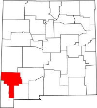 | |
| Towns | ||
| Village | ||
| CDPs | ||
| Other unincorporated communities | ||
| Ghost towns | ||
This article is issued from Wikipedia - version of the 11/10/2016. The text is available under the Creative Commons Attribution/Share Alike but additional terms may apply for the media files.