Buckhorn State Park
| Buckhorn State Park | |
| Wisconsin State Park | |
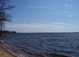 Wisconsin River in Buckhorn State Park | |
| Country | United States |
|---|---|
| State | Wisconsin |
| County | Juneau |
| Location | Necedah |
| - coordinates | 43°56′21″N 90°0′14″W / 43.93917°N 90.00389°WCoordinates: 43°56′21″N 90°0′14″W / 43.93917°N 90.00389°W |
| Area | 6,990 acres (2,829 ha) |
| Founded | 1971 |
| Management | Wisconsin Department of Natural Resources |
| IUCN category | V - Protected Landscape/Seascape |
 | |
Buckhorn State Park is a 6,990-acre (2,829 ha) Wisconsin state park southeast of Necedah. The park occupies a peninsula on Castle Rock Lake, a reservoir formed at the confluence of the Wisconsin and Yellow Rivers.
Images
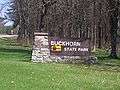 Sign
Sign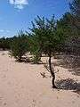 Sandy area
 Buckhorn Barrens, a State Natural Area
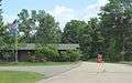 Office
External links
| Wikimedia Commons has media related to Buckhorn State Park. |
This article is issued from Wikipedia - version of the 1/19/2015. The text is available under the Creative Commons Attribution/Share Alike but additional terms may apply for the media files.