Burningtree Mountain, Alabama
| Burningtree Mountain, Alabama | |
|---|---|
| Unincorporated community | |
 Burningtree Mountain, Alabama Location in Alabama. | |
| Coordinates: 34°31′05″N 86°55′17″W / 34.51806°N 86.92139°W | |
| Country | United States |
| State | Alabama |
| County | Morgan |
| Elevation | 827 ft (252 m) |
| Time zone | Central (CST) (UTC-6) |
| • Summer (DST) | CDT (UTC-5) |
| Area code(s) | 256 |
| GNIS feature ID | 115250[1] |
Burningtree Mountain is a large, unincorporated community, existing mostly as a subdivision inside the city of Decatur, Alabama in Morgan County, and is included in the Decatur Metropolitan Area, as well as the Huntsville-Decatur Combined Statistical Area.
See also
References
Municipalities and communities of Morgan County, Alabama, United States | ||
|---|---|---|
| Cities | 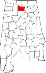 | |
| Towns | ||
| Unincorporated communities | ||
| Ghost town | ||
| Footnotes | ‡This populated place also has portions in an adjacent county or counties | |
This article is issued from Wikipedia - version of the 11/29/2015. The text is available under the Creative Commons Attribution/Share Alike but additional terms may apply for the media files.