Bynum, Montana
| Bynum, Montana | |
|---|---|
| Census-designated place & Unincorporated community (CDP) | |
 Bynum, Montana  Bynum, Montana | |
| Coordinates: 47°58′45″N 112°18′42″W / 47.97917°N 112.31167°WCoordinates: 47°58′45″N 112°18′42″W / 47.97917°N 112.31167°W | |
| Country | United States |
| State | Montana |
| County | Teton |
| Area[1] | |
| • Total | 1.628 sq mi (4.22 km2) |
| • Land | 1.628 sq mi (4.22 km2) |
| • Water | 0 sq mi (0 km2) |
| Elevation | 3,976 ft (1,212 m) |
| Population (2010)[2] | |
| • Total | 31 |
| • Density | 19/sq mi (7.4/km2) |
| Time zone | Mountain (MST) (UTC-7) |
| • Summer (DST) | MDT (UTC-6) |
| Area code(s) | 406 |
| GNIS feature ID | 769461[3] |
Bynum is an unincorporated community and census-designated place in Teton County, Montana, United States, about 13 miles north of Choteau.[3] Its population was 31 as of the 2010 census.[2]
Bynum is the site of a one-room country school, a general store, post office, an agate shop, and Two Medicine Dinosaur Center, which provides displays and educational programs about dinosaurs.
The town's name is derived from name of a family of early settlers in the area.
Notes
- ↑ "US Gazetteer files: 2010, 2000, and 1990". United States Census Bureau. 2011-02-12. Retrieved 2011-04-23.
- 1 2 "American FactFinder". United States Census Bureau. Archived from the original on 2013-09-11. Retrieved 2011-05-14.
- 1 2 "Bynum, Montana". Geographic Names Information System. United States Geological Survey.
External links
Municipalities and communities of Teton County, Montana, United States | ||
|---|---|---|
| City | 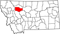 | |
| Towns | ||
| CDPs | ||
| Unincorporated communities | ||
This article is issued from Wikipedia - version of the 11/11/2016. The text is available under the Creative Commons Attribution/Share Alike but additional terms may apply for the media files.