Caneva
| Caneva | |
|---|---|
| Comune | |
| Comune di Caneva | |
 Caneva Location of Caneva in Italy | |
| Coordinates: 45°58′N 12°27′E / 45.967°N 12.450°ECoordinates: 45°58′N 12°27′E / 45.967°N 12.450°E | |
| Country | Italy |
| Region | Friuli-Venezia Giulia |
| Province / Metropolitan city | Province of Pordenone (PN) |
| Area | |
| • Total | 42.0 km2 (16.2 sq mi) |
| Population (Dec. 2004) | |
| • Total | 6,374 |
| • Density | 150/km2 (390/sq mi) |
| Time zone | CET (UTC+1) |
| • Summer (DST) | CEST (UTC+2) |
| Postal code | 33070 |
| Dialing code | 0434 |
| Website | Official website |
Caneva is a comune (municipality) in the Province of Pordenone in the Italian region Friuli-Venezia Giulia, located about 110 kilometres (68 mi) northwest of Trieste and about 15 kilometres (9 mi) west of Pordenone. As of 31 December 2004, it had a population of 6,374 and an area of 42.0 square kilometres (16.2 sq mi).[1]
Caneva borders the following municipalities: Cordignano, Fontanafredda, Fregona, Polcenigo, Sacile, Sarmede, Tambre.
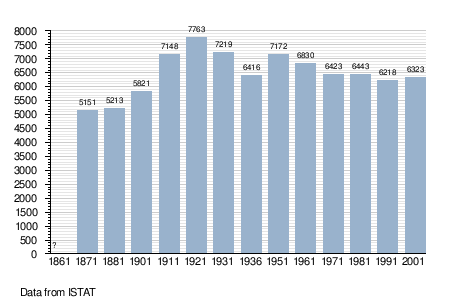
Demographic evolution
Twin towns
Caneva is twinned with:
-
 Neumarkt-Sankt Veit, Germany, since 2002
Gallery
 The Castello di Caneva
References
External links
| Wikimedia Commons has media related to Caneva. |
This article is issued from Wikipedia - version of the 11/13/2016. The text is available under the Creative Commons Attribution/Share Alike but additional terms may apply for the media files.