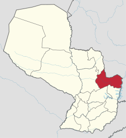
Canindeyú Department
| Canindeyú | |||
|---|---|---|---|
| Department | |||
| |||
 | |||
| Coordinates: 24°1′S 54°20′W / 24.017°S 54.333°WCoordinates: 24°1′S 54°20′W / 24.017°S 54.333°W | |||
| Country |
| ||
| Capital | Salto del Guairá | ||
| Government | |||
| • Governor | Alfonso Noria Duarte (ANR) | ||
| Area | |||
| • Total | 14,667 km2 (5,663 sq mi) | ||
| Population (2002) | |||
| • Total | 140,551 | ||
| • Density | 9.6/km2 (25/sq mi) | ||
| Time zone | AST (UTC-04) | ||
| • Summer (DST) | ADT (UTC-03) | ||
| ISO 3166 code | PY-14 | ||
| Number of Districts | 10 | ||
Canindeyú (Spanish pronunciation: [kanindeˈʝu]) is a department in Paraguay. The capital is the city of Salto del Guairá. Canindeyú comes from the Guarani words Kaninde - macaw; ju - yellow, blue-and-yellow macaw (Ara ararauna).
Districts
The department is divided in 13 districts:
- Corpus Christi
- Curuguaty
- General Francisco Caballero Alvarez (Puente Kyhá)
- Itanará
- Katueté
- La Paloma
- Nueva Esperanza
- Salto del Guairá
- Villa Ygatimí
- Yasy Cañy
- Ypehú
- Ybyrarobaná
- Yby Pytá
The eastern part of Canindeyu is very green; mostly rolling hills and soy bean farms. A fair portion of the population consists of Brazilian immigrants.
See also
| Wikimedia Commons has media related to Canindeyú Department. |
This article is issued from Wikipedia - version of the 3/11/2016. The text is available under the Creative Commons Attribution/Share Alike but additional terms may apply for the media files.