Casa Branca, Sousel
| Casa Branca | ||
|---|---|---|
| Parish | ||
| ||
 Casa Branca | ||
| Coordinates: 38°57′00″N 7°48′33″W / 38.949935°N 7.809054°WCoordinates: 38°57′00″N 7°48′33″W / 38.949935°N 7.809054°W | ||
| Country | Portugal | |
| Region | Alentejo | |
| Subregion | Alto Alentejo | |
| Intermunic. comm. | Alto Alentejo | |
| District | Portalegre | |
| Municipality | Sousel | |
| Postal code | 7470 | |

Casa Branca (English: White House) is a civil parish in the municipality of Sousel.[1][2][3]
Location and statistics
-
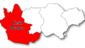
Location in Sousel Municipality
-
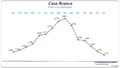
Population by year
-
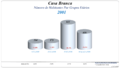
Population by age group in 2001
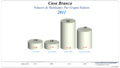
-
Population by age group in 2011
References
- ↑ "Município do Sousel". Sousel Municipality (in Portuguese). Retrieved 6 July 2016.
- ↑ "Junta de Freguesia de Casa Branca". Páginas Amarelas (yellow pages) (in Portuguese). Retrieved 6 July 2016.
- ↑ "Código Postal da Rua do Posto". Código Postal (in Portuguese). Retrieved 6 July 2016.
This article is issued from Wikipedia - version of the 7/6/2016. The text is available under the Creative Commons Attribution/Share Alike but additional terms may apply for the media files.