Chamois, Aosta Valley
| Chamois | ||
|---|---|---|
| Comune | ||
| Comune di Chamois Commune de Chamois | ||
| ||
 Chamois Location of Chamois in Italy | ||
| Coordinates: 45°50′N 7°37′E / 45.833°N 7.617°ECoordinates: 45°50′N 7°37′E / 45.833°N 7.617°E | ||
| Country | Italy | |
| Region | Valle d'Aosta | |
| Province / Metropolitan city | none | |
| Frazioni | Caillaz, Corgnolaz, Crépin, La Ville, Lac de Lod, Liussel, Suisse[1] | |
| Area | ||
| • Total | 14 km2 (5 sq mi) | |
| Elevation | 1,800 m (5,900 ft) | |
| Population (31 December 2006) | ||
| • Total | 96 | |
| • Density | 6.9/km2 (18/sq mi) | |
| Demonym(s) | Chamoisiens | |
| Time zone | CET (UTC+1) | |
| • Summer (DST) | CEST (UTC+2) | |
| Postal code | 11020 | |
| Dialing code | 0166 | |
| Patron saint | Saint Pantaleon | |
| Saint day | 26 July | |
| Website | Official website | |
.svg.png)
Chamois is a town and comune in the Aosta Valley region of northwestern Italy.
Chamois is the only municipality in Italy not navigable by car. Visitors can arrive in Chamois with a cablecar or by a path from La Magdaleine.
Gallery
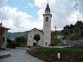 The church of Chamois
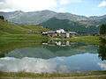 The mountain lake Lod
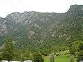 The plateau of Chamois seen from Buisson
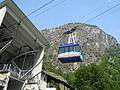 Cable car station in Buisson
See also
 Media related to Chamois at Wikimedia Commons
References
External links
This article is issued from Wikipedia - version of the 9/22/2016. The text is available under the Creative Commons Attribution/Share Alike but additional terms may apply for the media files.