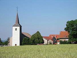
Champdray
| Champdray | |
|---|---|
 | |
 Champdray | |
|
Location within Grand Est region 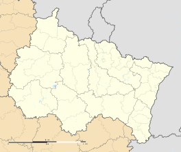 Champdray | |
| Coordinates: 48°08′10″N 6°45′13″E / 48.1361°N 6.7536°ECoordinates: 48°08′10″N 6°45′13″E / 48.1361°N 6.7536°E | |
| Country | France |
| Region | Grand Est |
| Department | Vosges |
| Arrondissement | Saint-Dié-des-Vosges |
| Canton | Corcieux |
| Intercommunality | Monts de Vologne |
| Government | |
| • Mayor (2008–2014) | Élisabeth Klipfel |
| Area1 | 9.49 km2 (3.66 sq mi) |
| Population (2006)2 | 170 |
| • Density | 18/km2 (46/sq mi) |
| Time zone | CET (UTC+1) |
| • Summer (DST) | CEST (UTC+2) |
| INSEE/Postal code | 88085 / 88640 |
| Elevation |
589–809 m (1,932–2,654 ft) (avg. 712 m or 2,336 ft) |
|
1 French Land Register data, which excludes lakes, ponds, glaciers > 1 km² (0.386 sq mi or 247 acres) and river estuaries. 2 Population without double counting: residents of multiple communes (e.g., students and military personnel) only counted once. | |
Champdray is a commune in the Vosges department in Grand Est in northeastern France. Champdray is situated in the Vosges, Lorraine region (now part of the Grand-Est region), in the north-east of France at 23 km from Epinal, the department capital.[1]
See also
References
| Wikimedia Commons has media related to Champdray. |
This article is issued from Wikipedia - version of the 12/2/2016. The text is available under the Creative Commons Attribution/Share Alike but additional terms may apply for the media files.