Choco District
| Choco | |
|---|---|
| District | |
|
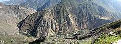
Apachita mountain and Qullqa River on the border of the districts of Choco (on the left) and Tapay | |
| Country |
|
| Region | Arequipa |
| Province | Castilla |
| Founded | January 2, 1857 |
| Capital | Choco |
| Government | |
| • Mayor | Trifonio Lucas Aragon Lupaca |
| Area | |
| • Total | 904.33 km2 (349.16 sq mi) |
| Elevation | 2,473 m (8,114 ft) |
| Population (2005 census) | |
| • Total | 1,235 |
| • Density | 1.4/km2 (3.5/sq mi) |
| Time zone | PET (UTC-5) |
| UBIGEO | 040406 |
Choco District is one of fourteen districts of the province Castilla in Peru.[1]
Geography
The Chila mountain range traverses the district. One of the highest mountains of the district is Chila at 5,654 m (18,550 ft) above sea level. Other mountains are listed below:[2]
|
|
Ethnic groups
The people in the district are mainly indigenous citizens of Quechua descent. Quechua is the language which the majority of the population (67.11%) learnt to speak in childhood, 32.23% of the residents started speaking using the Spanish language (2007 Peru Census).[3]
References
- ↑ (Spanish) Instituto Nacional de Estadística e Informática. Banco de Información Distrital Archived April 23, 2008, at the Wayback Machine.. Retrieved April 11, 2008.
- ↑ escale.minedu.gob.pe - UGEL maps of the Caylloma Province 1 and 2 (Arequipa Region)
- ↑ inei.gob.pe Archived January 27, 2013, at the Wayback Machine. INEI, Peru, Censos Nacionales 2007, Frequencias: Preguntas de Población: Idioma o lengua con el que aprendió hablar (in Spanish)
Coordinates: 15°34′34″S 72°07′59″W / 15.5761°S 72.1331°W
This article is issued from Wikipedia - version of the 11/22/2016. The text is available under the Creative Commons Attribution/Share Alike but additional terms may apply for the media files.