Clarysville, Maryland
| Clarysville, Maryland | |
|---|---|
| Census-designated place | |
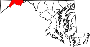
  Location within the state of Maryland | |
| Coordinates: 39°38′31″N 78°53′11″W / 39.64194°N 78.88639°WCoordinates: 39°38′31″N 78°53′11″W / 39.64194°N 78.88639°W | |
| Country | United States |
| State | Maryland |
| County | Allegany |
| Area | |
| • Total | 0.1 sq mi (0.3 km2) |
| • Land | 0.1 sq mi (0.3 km2) |
| • Water | 0 sq mi (0 km2) |
| Elevation | 1,500 ft (500 m) |
| Population (2010) | |
| • Total | 73 |
| • Density | 624/sq mi (241.1/km2) |
| Time zone | Eastern (EST) (UTC-5) |
| • Summer (DST) | EDT (UTC-4) |
| FIPS code | 24-17475 |
| GNIS feature ID | 2583599 |
Clarysville is an unincorporated community and census-designated place (CDP) in Allegany County, Maryland, United States. As of the 2010 census it had a population of 73.[1]
It is located along U.S. Route 40 Alternate at its intersection with Maryland Route 55. Frostburg is 2 miles (3 km) to the west, and Cumberland is 7 miles (11 km) to the east along Route 40 Alt.
Clarysville was known around the region for the Clarysville Inn, a historic building which stood from 1807 until it burned in 1999.[2] During the American Civil War, the inn served as a military hospital, treating wounded soldiers.[3]
The exit of the Hoffman drainage tunnel, constructed to drain several coal mines, is near Clarysville.
References
- ↑ "Geographic Identifiers: 2010 Demographic Profile Data (G001): Clarysville CDP, Maryland". U.S. Census Bureau, American Factfinder. Retrieved May 23, 2013.
- ↑ Cumberland Times-News Articles, March 10-11, 1999
- ↑ Clarysville General Hospital
This article is issued from Wikipedia - version of the 10/29/2016. The text is available under the Creative Commons Attribution/Share Alike but additional terms may apply for the media files.