Colón District, Panama
| Colón District | |
|---|---|
| District | |
 | |
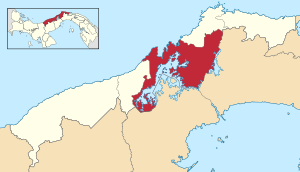 | |
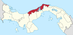
 Colón District Location of the district capital in Panama | |
| Coordinates: 9°20′N 79°54′W / 9.333°N 79.900°WCoordinates: 9°20′N 79°54′W / 9.333°N 79.900°W | |
| Country |
|
| Province | Colón Province |
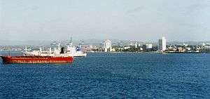
| Capital | Colón City |
| Area | |
| • Total | 581 sq mi (1,505 km2) |
| Population (2000) | |
| • Total | 174,059 |
| Time zone | ETZ (UTC-5) |
Colón District is a district (distrito) of Colón Province in Panama. The population according to the 2000 census was 174,059.[1] The district covers a total area of 1505 km². The capital lies at the city of Colón City.[1]
Administrative divisions
The district is divided administratively into the following corregimientos:
Colón City (capital). Corregimientos include Barrio Norte, Barrio Sur, Buena Vista, Cativá, Ciricito, Sabanitas, Salamanca, Limón, Nueva Providencia, Puerto Pilón, Cristóbal, Escobal, San Juan and Santa Rosa.
References
- 1 2 "Districts of Panama". Statoids. Retrieved April 10, 2009.
| Bocas del Toro Province | |
|---|---|
| Chiriquí Province | |
| Coclé Province | |
| Colón Province | |
| Darién Province | |
| Herrera Province | |
| Los Santos Province | |
| Panamá Province | |
| Veraguas Province | |
| West Panamá Province | |
This article is issued from Wikipedia - version of the 10/4/2015. The text is available under the Creative Commons Attribution/Share Alike but additional terms may apply for the media files.