Cordesville, South Carolina
| Cordesville, South Carolina | |
|---|---|
| Unincorporated community | |
 Cordesville  Cordesville | |
| Coordinates: 33°07′56″N 79°53′00″W / 33.13222°N 79.88333°WCoordinates: 33°07′56″N 79°53′00″W / 33.13222°N 79.88333°W | |
| Country | United States |
| State | South Carolina |
| County | Berkeley |
| Elevation | 52 ft (16 m) |
| Time zone | Eastern (EST) (UTC-5) |
| • Summer (DST) | EDT (UTC-4) |
| ZIP code | 29434 |
| Area code(s) | 843 |
| GNIS feature ID | 1247384[1] |
Cordesville is an unincorporated community in Berkeley County, South Carolina, United States.[1] The community is located on South Carolina Highway 402 8.7 miles (14.0 km) east-southeast of Moncks Corner. Cordesville has a post office with ZIP code 29434.[2][3]
References
- 1 2 "Cordesville". Geographic Names Information System. United States Geological Survey.
- ↑ United States Postal Service. "USPS - Look Up a ZIP Code". Retrieved October 30, 2016.
- ↑ "Postmaster Finder - Post Offices by ZIP Code". United States Postal Service. Retrieved October 30, 2016.
Municipalities and communities of Berkeley County, South Carolina, United States | ||
|---|---|---|
| Cities | 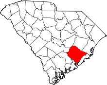 | |
| Towns | ||
| CDPs | ||
| Other unincorporated communities | ||
| Footnotes | ‡This populated place also has portions in an adjacent county or counties | |
This article is issued from Wikipedia - version of the 10/30/2016. The text is available under the Creative Commons Attribution/Share Alike but additional terms may apply for the media files.