Cornhill-on-Tweed
| Cornhill-on-Tweed | |
 Cornhill-on-Tweed |
|
| Population | 347 (2011 census)[1] |
|---|---|
| OS grid reference | NT865395 |
| Unitary authority | Northumberland |
| Ceremonial county | Northumberland |
| Region | North East |
| Country | England |
| Sovereign state | United Kingdom |
| Post town | CORNHILL-ON-TWEED |
| Postcode district | TD12 |
| Dialling code | 01890 |
| Police | Northumbria |
| Fire | Northumberland |
| Ambulance | North East |
| EU Parliament | North East England |
| UK Parliament | Berwick-upon-Tweed |
|
|
Coordinates: 55°38′53″N 2°12′58″W / 55.648°N 2.216°W
Cornhill-on-Tweed is a small village and civil parish in Northumberland, England about 1 mile (1.6 km) to the east of Coldstream, Scotland. The hamlets of West Learmouth and East Learmouth are located to the south and west of the village respectively.
History
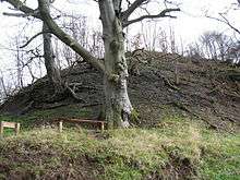
A mile north-west of the village, on a spur above the River Tweed are the earthwork remains of Cornhill Castle.
Transport
Cornhill-on-Tweed lies at a junction of the A697 and A698 roads - the latter linking to Berwick-upon-Tweed, the nearest significant town, some 13 miles (21 km) away.
Education
The village lacks any schools, so pupils are sent to schools nearby. It formerly had a school known as Cornhill School, which was built in 1837 and closed in 2012.[2]
See also
- Cornhill Branch
- Campfield Kettle Hole and Barelees Pond - Sites of Special Scientific Interest 0.7 miles (1.1 km) south, and 0.95 miles (1.53 km) south-east of Cornhill.
References
- ↑ "Parish population 2011". Retrieved 30 June 2015.
- ↑ "Cornhill-on-Tweed". Retrieved 9 July 2016.
External links
![]() Media related to Cornhill-on-Tweed at Wikimedia Commons
Media related to Cornhill-on-Tweed at Wikimedia Commons
- The official Cornhill-on-Tweed Parish Website
- A Village Website
- GENUKI (Accessed: 21 November 2008)