Cupra Marittima
| Cupra Marittima | |
|---|---|
| Comune | |
| Comune di Cupra Marittima | |
|
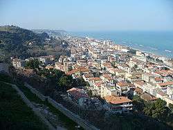
View from the old town | |
 Cupra Marittima Location of Cupra Marittima in Italy | |
| Coordinates: 43°1′N 13°52′E / 43.017°N 13.867°ECoordinates: 43°1′N 13°52′E / 43.017°N 13.867°E | |
| Country | Italy |
| Region | Marche |
| Province / Metropolitan city | Province of Ascoli Piceno (AP) |
| Government | |
| • Mayor | Giuseppe Torquati |
| Area | |
| • Total | 17.2 km2 (6.6 sq mi) |
| Elevation | 4 m (13 ft) |
| Population (2008) | |
| • Total | 5,252 |
| • Density | 310/km2 (790/sq mi) |
| Demonym(s) | Cuprensi |
| Time zone | CET (UTC+1) |
| • Summer (DST) | CEST (UTC+2) |
| Postal code | 63012 |
| Dialing code | 0735 |
| Patron saint | Saint Bassus (San Basso) |
| Saint day | December 5 |
| Website | Official website |
Cupra Marittima (Latin: Cupra Maritima)[1] is a comune (municipality) in the Province of Ascoli Piceno[2] in the Italian region Marche, located about 70 kilometres (43 mi) southeast of Ancona and about 30 kilometres (19 mi) northeast of Ascoli Piceno. As of 1 January 2008, it had a population of 5,252 and an area of 17.2 square kilometres (6.6 sq mi).[3]
Cupra Marittima borders the following municipalities: Grottammare, Massignano, Ripatransone.
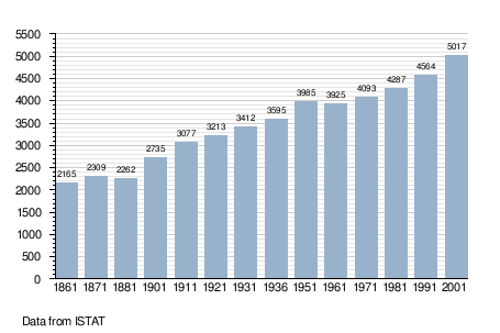
Demographic evolution
References
- ↑ Richard J.A. Talbert, ed. (2000). Barrington Atlas of the Greek and Roman World: Map-By-Map Directory. I. Princeton, NJ and Oxford, UK: Princeton University Press. p. 608. ISBN 0691049459.
- ↑ Harris, W. "Places: 413112 (Cupra Maritima)". Pleiades. Retrieved May 31, 2016.
- ↑ All demographics and other statistics: Italian statistical institute Istat.
External links
This article is issued from Wikipedia - version of the 9/16/2016. The text is available under the Creative Commons Attribution/Share Alike but additional terms may apply for the media files.