D508 road (Croatia)
| |
|---|---|
| Route information | |
| Length: | 19.2 km (11.9 mi) |
| Major junctions | |
| From: |
|
| To: |
|
| Location | |
| Counties: | Krapina-Zagorje |
| Major cities: | Đurmanec |
| Highway system | |
| State roads in Croatia | |

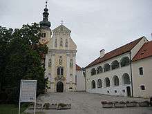
Lepoglava, at the southern terminus of the D508 road
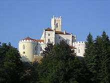
Trakošćan Castle, near the D508 road route
D508 is a state road in Hrvatsko Zagorje region of Croatia connecting Macelj border crossing to Slovenia[1] and the A2 motorway Trakošćan interchange to the city of Lepoglava and to Trakošćan.[2] The road is 19.2 km (11.9 mi) long.[3]
The road, as well as all other state roads in Croatia, is managed and maintained by Hrvatske ceste, state owned company.[4]
Traffic volume
Traffic is regularly counted and reported by Hrvatske ceste, operator of the road.[5]
| D508 traffic volume | ||||
| Road | Counting site | AADT | ASDT | Notes |
| |
1102 Pleš (Bednja) | 1,259 | 1,662 | Adjacent to the Ž2099 junction. |
Road junctions and populated areas
| D508 junctions/populated areas | |
| Type | Slip roads/Notes |
| |
The western terminus of the road. |
| |
Trakošćan Ž2056 to Jazbina Cvetlinska. |
| |
Pleš |
| |
Ž2083 to Vranojelje, Vrbno and Šaša. |
| |
Bednja Ž2099 to Gornje Jesenje. |
| |
Rinkovec |
| |
Muničevec |
| |
Lepoglava The eastern terminus of the road. |
Sources
- 1 2 "Map of border crossings and customs office areas" (PDF). Customs Administration of the Republic of Croatia (in Croatian). March 6, 2008.
- ↑ "Regulation on motorway markings, chainage, interchange/exit/rest area numbers and names". Narodne novine (in Croatian). April 24, 2003.
- ↑ "Decision on categorization of public roads as state roads, county roads and local roads". Narodne novine (in Croatian). February 17, 2010.
- ↑ "Public Roads Act". Narodne novine (in Croatian). December 14, 2004.
- ↑ "Traffic counting on the roadways of Croatia in 2009 - digest" (PDF). Hrvatske ceste. May 1, 2010. Archived from the original (PDF) on July 21, 2011.
See also
This article is issued from Wikipedia - version of the 9/13/2016. The text is available under the Creative Commons Attribution/Share Alike but additional terms may apply for the media files.