Davisville, New Jersey
| Davisville, New Jersey | |
|---|---|
| Unincorporated community | |
|
Looking west towards CR 528 in Davisville | |
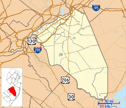 Davisville  Davisville  Davisville Location of Davisville in Burlington County (Inset: Location of county within the state of New Jersey) | |
| Coordinates: 40°06′35″N 74°37′05″W / 40.10972°N 74.61806°WCoordinates: 40°06′35″N 74°37′05″W / 40.10972°N 74.61806°W | |
| Country |
|
| State |
|
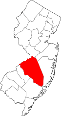
| County | Burlington |
| Township | Chesterfield |
| Elevation[1] | 102 ft (31 m) |
| Time zone | Eastern (EST) (UTC-5) |
| • Summer (DST) | EDT (UTC-4) |
| GNIS feature ID | 883070[1] |

Davisville is an unincorporated community located within Chesterfield Township in Burlington County, New Jersey, United States. The settlement, located at the intersection of County Route 528 and Chesterfield-Arneytown Road (CR 664), is in a rural area in the eastern portion of the township. It consists mainly of farmland with some houses dotting the few roads that pass through the area.[2]
References
- 1 2 "Davisville". Geographic Names Information System. United States Geological Survey.
- ↑ Google (March 15, 2015). "Davisville, Chesterfield Township, Burlington County, New Jersey 08515" (Map). Google Maps. Google. Retrieved March 15, 2015.
This article is issued from Wikipedia - version of the 6/21/2016. The text is available under the Creative Commons Attribution/Share Alike but additional terms may apply for the media files.