Devarakonda
This article is about the town in Telangana. For the town in Andhra Pradesh, see Devara Konda.
| Devarakonda | |
|---|---|
| Town | |
|
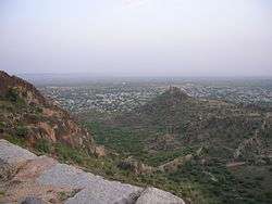
A view of Devarakonda Fort | |
 Devarakonda  Devarakonda Location in Telangana, India | |
| Coordinates: 16°42′00″N 78°56′00″E / 16.7000°N 78.9333°ECoordinates: 16°42′00″N 78°56′00″E / 16.7000°N 78.9333°E | |
| Country | India |
| State | Telangana |
| District | Nalgonda |
| Area[1] | |
| • Total | 28.18 km2 (10.88 sq mi) |
| Population (2011)[1] | |
| • Total | 29,731 |
| • Density | 1,100/km2 (2,700/sq mi) |
| Languages | |
| • Official | Telugu |
| Time zone | IST (UTC+5:30) |
| Vehicle registration | TS |
| Website |
telangana |
Devarakonda is a town in the Nalgonda district of the Indian state of Telangana. It is a nagar panchayat in Devarakonda mandal of Devarakonda division.[2][3]
Demographics
As of 2001 India census, Devarakonda had a population of 37,434. Males constitute 53% of the population and females 47%. Devarakonda has an average literacy rate of 72%, higher than the national average of 59.5%: male literacy is 81% and, female literacy is 63%. In Devarakonda, 12% of the population is under 6 years of age.[4]
References
- 1 2 "District Census Handbook - Nalgonda" (PDF). Census of India. p. 13,386. Retrieved 15 February 2016.
- ↑ "Division wise mandals list" (PDF). Official website of Nalgonda district. National Informatics Centre. pp. 11–12. Retrieved 15 February 2016.
- ↑ "Nalgonda district info". Official website of Nalgonda district. National Informatics Centre. Retrieved 16 February 2016.
- ↑ "Census of India 2001: Data from the 2001 Census, including cities, villages and towns (Provisional)". Census Commission of India. Archived from the original on 2004-06-16. Retrieved 2008-11-01.
External links
This article is issued from Wikipedia - version of the 10/4/2016. The text is available under the Creative Commons Attribution/Share Alike but additional terms may apply for the media files.