Dingolshausen
| Dingolshausen | ||
|---|---|---|
| ||
 Dingolshausen | ||
Location of Dingolshausen within Schweinfurt district 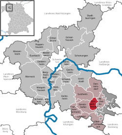 | ||
| Coordinates: 49°54′N 10°24′E / 49.900°N 10.400°ECoordinates: 49°54′N 10°24′E / 49.900°N 10.400°E | ||
| Country | Germany | |
| State | Bavaria | |
| Admin. region | Unterfranken | |
| District | Schweinfurt | |
| Municipal assoc. | Gerolzhofen | |
| Government | ||
| • Mayor | Lothar Zachmann | |
| Area | ||
| • Total | 10.23 km2 (3.95 sq mi) | |
| Population (2015-12-31)[1] | ||
| • Total | 1,322 | |
| • Density | 130/km2 (330/sq mi) | |
| Time zone | CET/CEST (UTC+1/+2) | |
| Postal codes | 97497 | |
| Dialling codes | 09382 | |
| Vehicle registration | SW | |
| Website | www.dingolshausen.de | |

Dingolshausen is a municipality in the district of Schweinfurt in Bavaria, Germany. Dingolshausen is a Village in the district of Schweinfurt in Bavaria, Germany. Located at the foot of the Steigerwald (forest) and in the valley of a creek named the Volkach. Dingolshausen is mostly famous for their wineries. Kohler is known throughout Germany and the rest of the world.
Coat of Arms: The coat of arms (Wappen) was given to Dingolshausen in the year 1561. It shows two grapes as a symbol of the winemakers (Winzwer).
History: - 1165 first documented as Dingolshausens, which was later in the year of 1243 ruled by The Bishopric of Würzburg (Hochstift Wuerzburg).
Web-links: Commons: Dingolshausen (http://commons.wikimedia.org/wiki/Category:Dingolshausen?uselang=de) Collection of pictures and videos of the village.
References
- ↑ "Fortschreibung des Bevölkerungsstandes". Bayerisches Landesamt für Statistik und Datenverarbeitung (in German). June 2016.