Doi Phi Pan Nam
For the mountain chain, see Phi Pan Nam Range.
| Doi Phi Pan Nam | |
|---|---|
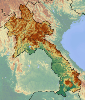 Doi Phi Pan Nam Location on the Lao–Thai border | |
| Highest point | |
| Elevation | 1,745 m (5,725 ft) |
| Listing | List of mountains in Thailand |
| Coordinates | 19°07′33″N 101°15′22″E / 19.12583°N 101.25611°ECoordinates: 19°07′33″N 101°15′22″E / 19.12583°N 101.25611°E [1] |
| Geography | |
| Location | Lao – Thai border |
| Parent range | Luang Prabang Range |
| Climbing | |
| First ascent | unknown |
| Easiest route | hike |
Doi Phi Pan Nam, Thai: ดอยผีปันน้ำ, is a 1,745 m high mountain in Southeast Asia, part of the Luang Prabang Range (ทิวเขาหลวงพระบาง).[2]
It is located at the eastern end of the Thai highlands, on the international border between Laos and Thailand. The Wa River has its source beneath this mountain.[3]
See also
References
- ↑ Google Earth
- ↑ ดร.กระมล ทองธรรมชาติ และคณะ, สังคมศึกษา ศาสนาและวัฒนธรรม ม.1, สำนักพิมพ์ อักษรเจริญทัศน์ อจท. จำกัด, 2548, หน้า 24-25
- ↑ Khun Nan National Park - Trekthailand
External links
This article is issued from Wikipedia - version of the 3/28/2013. The text is available under the Creative Commons Attribution/Share Alike but additional terms may apply for the media files.