Englewood station
Englewood Station | |||||||||||||||
|---|---|---|---|---|---|---|---|---|---|---|---|---|---|---|---|
| TheRide light rail station | |||||||||||||||
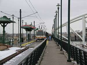 A 'D-Line' train at Englewood Station | |||||||||||||||
| Location |
899 West Floyd Avenue Englewood, Colorado | ||||||||||||||
| Coordinates | 39°39′20″N 105°00′00″W / 39.655611°N 104.99994°WCoordinates: 39°39′20″N 105°00′00″W / 39.655611°N 104.99994°W | ||||||||||||||
| Owned by | Regional Transportation District | ||||||||||||||
| Line(s) | |||||||||||||||
| Platforms | 1 side platform, 1 island platform | ||||||||||||||
| Tracks | 2 | ||||||||||||||
| Connections | TheRide buses | ||||||||||||||
| Construction | |||||||||||||||
| Structure type | Elevated | ||||||||||||||
| Parking | 910 spaces[1] | ||||||||||||||
| Bicycle facilities | 24 racks, 32 lockers | ||||||||||||||
| Disabled access | Yes | ||||||||||||||
| Other information | |||||||||||||||
| Fare zone | B | ||||||||||||||
| History | |||||||||||||||
| Opened | July 14, 2000 | ||||||||||||||
| Traffic | |||||||||||||||
| Passengers (2014) |
6,306 (avg. weekday)[2] | ||||||||||||||
| Rank | 10 out of 44[3] | ||||||||||||||
| Services | |||||||||||||||
| |||||||||||||||
Englewood Station is a RTD light rail station in Englewood, Colorado, United States. Operating as part of the C and D Lines, the station was opened on July 14, 2000, and is operated by the Regional Transportation District.[4][5] It serves the Englewood City Center, site of the former Cinderella City Mall.[6]
References
- ↑ "Alphabetical park-n-Ride List". Regional Transportation District. Retrieved September 26, 2010.
- ↑ http://www.rtd-denver.com/PDF_Files/ServiceD/RiderStats_LRT_Station_Activity_Wkday_Aug14.pdf
- ↑ http://www.rtd-denver.com/PDF_Files/ServiceD/RiderStats_LRT_Station_Activity_Wkday_Aug14.pdf
- ↑ Medina, Jennifer (July 3, 2000). "Train lovers hop on board new light rail". The Denver Post. p. B1.
- ↑ "RTD: Southwest Corridor Light Rail Line" (PDF). Regional Transportation District. Retrieved September 27, 2010.
- ↑ "Light rail system map". Regional Transportation District. Retrieved September 26, 2010.
External links
This article is issued from Wikipedia - version of the 6/9/2016. The text is available under the Creative Commons Attribution/Share Alike but additional terms may apply for the media files.