Espelkamp
| Espelkamp | ||
|---|---|---|
| ||
 Espelkamp | ||
Location of Espelkamp within Minden-Lübbecke district 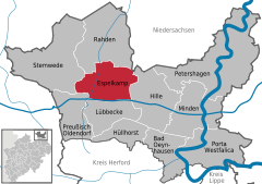
 | ||
| Coordinates: 52°22′38″N 8°37′58″E / 52.37722°N 8.63278°ECoordinates: 52°22′38″N 8°37′58″E / 52.37722°N 8.63278°E | ||
| Country | Germany | |
| State | North Rhine-Westphalia | |
| Admin. region | Detmold | |
| District | Minden-Lübbecke | |
| Government | ||
| • Mayor | Heinrich Vieker (CDU) | |
| • Governing parties | CDU | |
| Area | ||
| • Total | 84.1 km2 (32.5 sq mi) | |
| Population (2015-12-31)[1] | ||
| • Total | 24,921 | |
| • Density | 300/km2 (770/sq mi) | |
| Time zone | CET/CEST (UTC+1/+2) | |
| Postal codes | 32339 | |
| Dialling codes | 05772 | |
| Vehicle registration | MI | |
| Website | www.espelkamp.de | |

Espelkamp is a town in the Minden-Lübbecke district, in North Rhine-Westphalia, Germany.
Geography
Espelkamp is situated approximately 10 kilometers north of Lübbecke and 20 kilometers north-west of Minden.
Neighbouring places
Division of the town
After the local government reforms of 1973 Espelkamp consists of 9 districts:
| village | population 31. Dez. 2007[2] |
Stadtgliederung 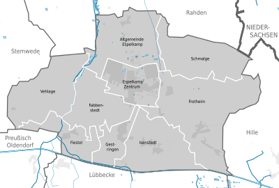 |
|---|---|---|
| Altgemeinde Espelkamp | 965 | |
| Fabbenstedt | 829 | |
| Fiestel | 1.023 | |
| Frotheim | 2.674 | |
| Gestringen | 1.834 | |
| Isenstedt | 2.658 | |
| Schmalge | 399 | |
| Vehlage | 618 | |
| Espelkamp Zentrum¹ | 15.553 | |
Twin Towns
-
 Angermünde (Brandenburg, Germany)
 -
 Borås (Sweden)
 -
 Nagykörös (Hungary)
 - Torgelow (Mecklenburg-Vorpommern, Germany)
References
- ↑ "Amtliche Bevölkerungszahlen". Landesbetrieb Information und Technik NRW (in German). 18 July 2016.
- ↑ Espelkamp: Stadtportrait, Statistik
External links
- Official site (German)
Towns and municipalities in Minden-Lübbecke | ||
|---|---|---|
This article is issued from Wikipedia - version of the 5/18/2015. The text is available under the Creative Commons Attribution/Share Alike but additional terms may apply for the media files.