Falknis
| Falknis | |
|---|---|
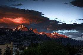 Falknis at sunset, photographed from Sargans in Switzerland | |
| Highest point | |
| Elevation | 2,562 m (8,406 ft) |
| Prominence | 60 m (200 ft) [1] |
| Parent peak | Grauspitz |
| Coordinates | 47°03′01.9″N 9°33′52.3″E / 47.050528°N 9.564528°ECoordinates: 47°03′01.9″N 9°33′52.3″E / 47.050528°N 9.564528°E |
| Geography | |
 Falknis Location in the Alps | |
| Location |
Graubünden, Switzerland Triesen, Liechtenstein |
| Parent range | Rätikon |
The Falknis is a mountain in the Rätikon range of the Alps, located on the border between Liechtenstein and Switzerland.
The nearest locality is Balzers.
References
- ↑ Approximation. Retrieved from the Swisstopo topographic maps and Google Earth. The key col is located west of the Vorder Grauspitz.
External links
This article is issued from Wikipedia - version of the 1/28/2016. The text is available under the Creative Commons Attribution/Share Alike but additional terms may apply for the media files.