Fließ
| Fließ | ||
|---|---|---|
 | ||
| ||
 Fließ Location within Austria | ||
| Coordinates: 47°07′12″N 10°37′39″E / 47.12000°N 10.62750°ECoordinates: 47°07′12″N 10°37′39″E / 47.12000°N 10.62750°E | ||
| Country | Austria | |
| State | Tyrol | |
| District | Landeck | |
| Government | ||
| • Mayor | Hans-Peter Bock | |
| Area | ||
| • Total | 47.56 km2 (18.36 sq mi) | |
| Elevation | 1,073 m (3,520 ft) | |
| Population (1 January 2016)[1] | ||
| • Total | 2,993 | |
| • Density | 63/km2 (160/sq mi) | |
| Time zone | CET (UTC+1) | |
| • Summer (DST) | CEST (UTC+2) | |
| Postal code | 6521 | |
| Area code | 05449 | |
| Vehicle registration | LA | |
| Website | www.fliess.tirol.gv.at | |

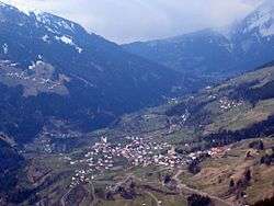
Fließ is a municipality in the Landeck district in the Austrian state of Tyrol located 5 km south of Landeck on the upper course of the Inn River. It has nine hamlets and was already populated at the Roman age; the village itself was founded around the 6th century. After a conflagration in 1933 Fließ was restored more spacious. The main source of income is tourism (especially skiing).
Population
| Historical population | ||
|---|---|---|
| Year | Pop. | ±% |
| 1869 | 2,093 | — |
| 1880 | 2,041 | −2.5% |
| 1890 | 1,787 | −12.4% |
| 1900 | 1,595 | −10.7% |
| 1910 | 1,473 | −7.6% |
| 1923 | 1,527 | +3.7% |
| 1934 | 1,696 | +11.1% |
| 1939 | 1,513 | −10.8% |
| 1951 | 1,860 | +22.9% |
| 1961 | 1,990 | +7.0% |
| 1971 | 2,280 | +14.6% |
| 1981 | 2,409 | +5.7% |
| 1991 | 2,881 | +19.6% |
| 2001 | 2,924 | +1.5% |
| 2011 | 2,910 | −0.5% |
References
External links
| Wikimedia Commons has media related to Fließ. |
This article is issued from Wikipedia - version of the 2/21/2016. The text is available under the Creative Commons Attribution/Share Alike but additional terms may apply for the media files.