Garab-e Sofla
| Garab-e Sofla گراب سفلي | |
|---|---|
| city | |
 Garab-e Sofla | |
| Coordinates: 30°56′50″N 50°53′16″E / 30.94722°N 50.88778°ECoordinates: 30°56′50″N 50°53′16″E / 30.94722°N 50.88778°E | |
| Country |
|
| Province | Kohgiluyeh and Boyer-Ahmad |
| County | Boyer-Ahmad |
| Bakhsh | Ludab |
| Population (2006) | |
| • Total | 416 |
| Time zone | IRST (UTC+3:30) |
| • Summer (DST) | IRDT (UTC+4:30) |
Garab-e Sofla (Persian: گراب سفلي; also Romanized as Garāb-e Sofla; also known as Garab-e-Pain (گراب پائين), also Romanized as Garāb-e Pā’īn)[1] is a city in and the capital of Ludab District, in Boyer-Ahmad County, Kohgiluyeh and Boyer-Ahmad Province, Iran. At the 2006 census, its population was 416, in 84 families.[2] Both "Sofla" and "Pain" mean "lower" in Persian.
References
- ↑ Garab-e Pain can be found at GEOnet Names Server, at this link, by opening the Advanced Search box, entering "-3757354" in the "Unique Feature Id" form, and clicking on "Search Database".
- ↑ "Census of the Islamic Republic of Iran, 1385 (2006)". Islamic Republic of Iran. Archived from the original (Excel) on 2011-11-11.
| Capital | 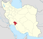 | ||||||||||||||||||||||||||||||
|---|---|---|---|---|---|---|---|---|---|---|---|---|---|---|---|---|---|---|---|---|---|---|---|---|---|---|---|---|---|---|---|
| Counties and cities | |||||||||||||||||||||||||||||||
| Sights |
| ||||||||||||||||||||||||||||||
| populated places | |||||||||||||||||||||||||||||||
This article is issued from Wikipedia - version of the 7/10/2013. The text is available under the Creative Commons Attribution/Share Alike but additional terms may apply for the media files.