Gorga, Lazio
For other uses, see Gorga.
| Gorga | |
|---|---|
| Comune | |
| Comune di Gorga | |
.svg.png) Gorga within the Province of Rome | |
 Gorga Location of Gorga in Italy | |
| Coordinates: 41°39′N 13°7′E / 41.650°N 13.117°ECoordinates: 41°39′N 13°7′E / 41.650°N 13.117°E | |
| Country | Italy |
| Region | Lazio |
| Province / Metropolitan city | Rome (RM) |
| Area | |
| • Total | 26.3 km2 (10.2 sq mi) |
| Elevation | 766 m (2,513 ft) |
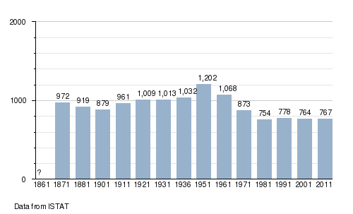
| Population (2011) | |
| • Total | 767 |
| • Density | 29/km2 (76/sq mi) |
| Demonym(s) | Gorgani |
| Time zone | CET (UTC+1) |
| • Summer (DST) | CEST (UTC+2) |
| Postal code | 00030 |
| Dialing code | 06 |
Gorga is a comune (municipality) in the Province of Rome in the Italian region Lazio, located about 60 kilometres (37 mi) southeast of Rome. As of 2011 census, it had a population of 767 and an area of 26.3 square kilometres (10.2 sq mi).[1]
Geography
Gorga borders the following municipalities: Anagni, Carpineto Romano, Montelanico, Morolo, Sgurgola, Supino.
Demographics
References
External links
![]() Media related to Gorga at Wikimedia Commons
Media related to Gorga at Wikimedia Commons
This article is issued from Wikipedia - version of the 11/23/2016. The text is available under the Creative Commons Attribution/Share Alike but additional terms may apply for the media files.