Gouville
| Gouville | |
|---|---|
|
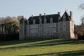
Chateau of Chambray | |
 Gouville | |
|
Location within Normandy region  Gouville | |
| Coordinates: 48°51′05″N 0°59′32″E / 48.8514°N 0.9922°ECoordinates: 48°51′05″N 0°59′32″E / 48.8514°N 0.9922°E | |
| Country | France |
| Region | Normandy |
| Department | Eure |
| Arrondissement | Évreux |
| Canton | Verneuil-sur-Avre |
| Government | |
| • Mayor (2008–2014) | Jacques Esprit |
| Area1 | 8.47 km2 (3.27 sq mi) |
| Population (2008)2 | 500 |
| • Density | 59/km2 (150/sq mi) |
| Time zone | CET (UTC+1) |
| • Summer (DST) | CEST (UTC+2) |
| INSEE/Postal code | 27293 / 27240 |
| Elevation |
140–180 m (460–590 ft) (avg. 169 m or 554 ft) |
|
1 French Land Register data, which excludes lakes, ponds, glaciers > 1 km² (0.386 sq mi or 247 acres) and river estuaries. 2 Population without double counting: residents of multiple communes (e.g., students and military personnel) only counted once. | |
Gouville is a former commune in the Eure department in northern France. On 1 January 2016, it was merged into the new commune of Mesnils-sur-Iton.[1]
Population
| Historical population | ||
|---|---|---|
| Year | Pop. | ±% |
| 1962 | 168 | — |
| 1968 | 253 | +50.6% |
| 1975 | 300 | +18.6% |
| 1982 | 240 | −20.0% |
| 1990 | 300 | +25.0% |
| 1999 | 287 | −4.3% |
| 2008 | 500 | +74.2% |
Notable people
- Alfred-Alexandre Delauney (1830–1894), painter and engraver[2]
See also
References
- ↑ Arrêté préfectoral 23 November 2015 (French)
- ↑ Annales (Société historique et archéologique de Château-Thierry, 1892), p. 250
| Wikimedia Commons has media related to Gouville. |
This article is issued from Wikipedia - version of the 3/24/2016. The text is available under the Creative Commons Attribution/Share Alike but additional terms may apply for the media files.