Gwale
| Gwale | |
|---|---|
| LGA and town | |
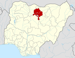
 Gwale Location in Nigeria | |
| Coordinates: 11°58′N 8°30′E / 11.967°N 8.500°ECoordinates: 11°58′N 8°30′E / 11.967°N 8.500°E | |
| Country |
|
| State | Kano State |
| Government | |
| • Type | Democratic |
| • Local Government Chairman and the Head of the Local Government Council | Alh. Abdullahi Zubair Imam |
| Area | |
| • Total | 18 km2 (7 sq mi) |
| Population (2006 census) | |
| • Total | 362,059 |
| Time zone | WAT (UTC+1) |
| 3-digit postal code prefix | 700 |
| ISO 3166 code | NG.KN.GL |
Gwale is a Local Government Area in Kano State, Nigeria within Greater Kano city. Its headquarters are in the suburb of Gwale.
It has an area of 18 km² and a population of 362,059 at the 2006 census.
The postal code of the area is 700.[1]
References
- ↑ "Post Offices- with map of LGA". NIPOST. Retrieved 2009-10-20.
This article is issued from Wikipedia - version of the 7/24/2015. The text is available under the Creative Commons Attribution/Share Alike but additional terms may apply for the media files.