Iguerande
| Iguerande | |
|---|---|
-20110330.jpg) | |
 Iguerande | |
|
Location within Bourgogne-Franche-Comté region  Iguerande | |
| Coordinates: 46°12′22″N 4°04′46″E / 46.2061°N 4.0794°ECoordinates: 46°12′22″N 4°04′46″E / 46.2061°N 4.0794°E | |
| Country | France |
| Region | Bourgogne-Franche-Comté |
| Department | Saône-et-Loire |
| Arrondissement | Charolles |
| Canton | Semur-en-Brionnais |
| Area1 | 21.43 km2 (8.27 sq mi) |
| Population (2006)2 | 1,023 |
| • Density | 48/km2 (120/sq mi) |
| Time zone | CET (UTC+1) |
| • Summer (DST) | CEST (UTC+2) |
| INSEE/Postal code | 71238 / 71340 |
| Elevation |
245–425 m (804–1,394 ft) (avg. 300 m or 980 ft) |
|
1 French Land Register data, which excludes lakes, ponds, glaciers > 1 km² (0.386 sq mi or 247 acres) and river estuaries. 2 Population without double counting: residents of multiple communes (e.g., students and military personnel) only counted once. | |
Iguerande is a commune in the Saône-et-Loire department in the region of Bourgogne in eastern France.
See also
References
Gallery
- Parish church Saint Marcel
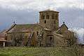 St Marcel's church.
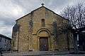 Forecourt view.
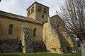 Buttres.
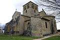 Bells tower.
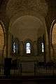 Oven bottom apse.
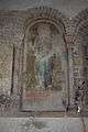 Saint with phylactery.
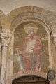 Saint Paul.
| Wikimedia Commons has media related to Iguerande. |
This article is issued from Wikipedia - version of the 10/28/2016. The text is available under the Creative Commons Attribution/Share Alike but additional terms may apply for the media files.