Imljani
| Imljani | |
|---|---|
 | |
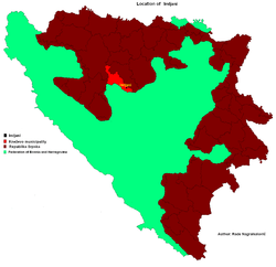 Location of Imljani in Bosnia and Herzegovina | |
| Coordinates: 44°24′N 17°28′E / 44.400°N 17.467°ECoordinates: 44°24′N 17°28′E / 44.400°N 17.467°E | |
| Country | Bosnia and Herzegovina |
| Entity | Republika Srpska |
| Municipality | Skender Vakuf/Kneževo |
| Population (1991) | |
| • Total | 1,565 |
| Time zone | EET (UTC+2) |
| • Summer (DST) | EEST (UTC+3) |
| Postal code | 78234 |
| Area code(s) | (+387) 51 |
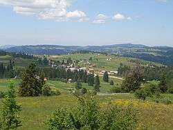
Imljani (Serbian Cyrillic: Имљани), is a village in Bosnia and Herzegovina, Entity of Republika Srpska, Skender Vakuf Municipality. It consists of a few hamlets spreading on the Undervlašić's plateau, above the canyons of Ilomska and Ugar rivers. Actually, it covers the sub-plateau in the area of the angle between Korićanske stijene and Ugarske stijene ("Rocks of Ugar").[1][2][3]
Central hamlet Vidovište is on (around) 1200 meters above sea level. Around Vidovište, from Kobilja river (south-west) to Ilomska's canyon (north-east) there are the hamlets, as follows - North-eastern: Rijeka, Potok, Ponorci, Osredok, Benići, Škeljići, Pušići, Marići, Đenići and Đekin Do; South-western: Vujinovići, Makarići, Kelemeni, Novakovići, Šodolovići and Borje.
Population
Ethnic composition, 1991 census
| Ethnic composition of Skender Vakuf municipality, by settlements, 1991. census | ||||||
| settlement | total | Serbs | Muslims | Croats | Yugoslavs | others |
| Imljani | 1,565 | 1,544 | 3 | 1 | 5 | 12 |
See also
References
- ↑ Vojnogeografski institut, Izd. (1955): Travnik (List karte 1:100.000, Izohipse na 20 m). Vojnogeografski institut, Beograd.
- ↑ Spahić M. et al. (2000): Bosna i Hercegovina (1:250.000). Izdavačko preduzeće „Sejtarija“, Sarajevo.
- ↑ Mučibabić B., Ed. (1998): Geografski atlas Bosne i Hercegovine. Geodetski zavod BiH, Sarajevo.