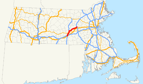
Interstate 290 (Massachusetts)
| ||||
|---|---|---|---|---|
 | ||||
| Route information | ||||
| Maintained by Masshighways | ||||
| Length: | 20.16 mi[1] (32.44 km) | |||
| Existed: | 1970 – present | |||
| Major junctions | ||||
| West end: |
| |||
| East end: |
| |||
| Highway system | ||||
| ||||

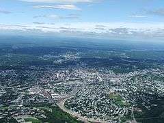
Interstate 290 (abbreviated I-290) runs for 20.16 miles (32.44 km) from Auburn, Massachusetts to Marlborough, Massachusetts. It is a continuation of I-395 north of I-90 (the Mass Pike) and runs through downtown Worcester, Massachusetts, where I-190 splits off, and I-290 runs across Lake Quinsigamond and east to I-495 in Marlborough. There are buildings very close to the highway, including a grand church which faces the road (referred to locally as "Our Lady of the Highway"). Massachusetts has built a freeway connector (Route 146) from I-290 in Worcester to the Mass Pike and then south to Providence, Rhode Island.
Route description
I-290 begins as the continuation of I-395 in Auburn with exits to I-90, Route 12, and the Auburn Mall. 290 continues north through Worcester into Downtown, where Route 146 and I-190 split off. After 146, I-290 has exits for Route 122A, Route 122, downtown, and Route 9. After 190, 290 presumes east to a junction with Route 70, then continues over Quinsigamond Lake into Shrewsbury, where it goes northeast. 290 has a junction with Route 140 and starts east into Boylston and Northborough, where it travels northeast again. 290 enters Berlin for a brief time with an exit for Solomon Pond Mall and then enters Marlborough with the junction with 495, where it terminates shortly after on the Route 85 connector.
History

Originally, I-290 was to rejoin I-90 in Westborough, roughly where I-495 sits now. However, this route would have run through the town centers of Shrewsbury and Northborough. Additionally, I-290 was intended to be extended past I-495 to I-95/Route 128 in Waltham, but this was canceled under pressure from towns along the planned route. A brief two-lane connector heads to Route 85 as a result of this aborted plan. The interchange with I-495 was originally supposed to be a cloverleaf, but after the plan was canceled, it was modified with a flyover ramp onto 495-northbound. The former exit 12 (Millbury Street) was closed when the Route 146 freeway was completed between the Mass Pike and I-290 in 2007.
Exit list
All interchanges will be renumbered to milepost-based numbers under a project scheduled to start in 2016.[2]
| County | Location[3] | mi[3] | km | Exit[4] | Destinations[4] | Notes |
|---|---|---|---|---|---|---|
| Worcester | Auburn | 0.000 | 0.000 | – | Western terminus; continuation from I-395 | |
| 0.347 | 0.558 | 7 | Eastbound exit to Route 12 south; westbound exit to Route 12 north; I-90 Exit 10 | |||
| 0.070 | 0.113 | 8 | Westbound exit only | |||
| 0.930 | 1.497 | 9 | Swanson Road – Auburn | Eastbound exit to Swanson Road; westbound entrance from Vine Street | ||
| 1.700 | 2.736 | Auburn Street – Auburn | Westbound exit and eastbound entrance | |||
| Worcester | 3.358 | 5.404 | 10 | Westbound exit and eastbound entrance | ||
| 3.565 | 5.737 | 11 | College Square / Federal Square / Southbridge Street | |||
| 4.611 | 7.421 | 12 | Westbound exit and eastbound entrance, the original exit 12 was for Millbury Street | |||
| 5.265 | 8.473 | 13 | Route 146 is accessible by 122A southbound | |||
| 5.638 | 9.073 | 14 | No westbound entrance | |||
| 5.810 | 9.350 | 15 | Shrewsbury Street | Eastbound exit and westbound entrance | ||
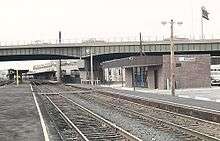
| 6.137 | 9.877 | 16 | E. Central St, MLK Jr. Boulevard – Downtown Worcester | Union Station, Saint Vincent Hospital, DCU Center | ||
| 6.572 | 10.577 | 17 | Eastbound exit and westbound entrance | |||
| 6.980 | 11.233 | 18 | Westbound exit and eastbound entrance | |||
| 7.377 | 11.872 | 19 | Southern terminus of I-190; eastbound exit is combined with Exit 20 | |||
| 7.377 | 11.872 | 20 | Burncoat Street to | Eastbound exit and westbound entrance; eastbound exit is combined with Exit 19 | ||
| 8.421 | 13.552 | Westbound exit and eastbound entrance | ||||
| 9.641 | 15.516 | 21 | Plantation Street – Worcester | Eastbound exit and westbound entrance | ||
| Shrewsbury | 10.173 | 16.372 | 22 | Main Street – Shrewsbury, Worcester | ||
| 12.680 | 20.406 | 23A | ||||
| 12.690 | 20.423 | 23B | ||||
| Northborough | 14.855 | 23.907 | 24 | Church Road – Northborough, Boylston | ||
| 17.913 | 28.828 | 25A | Hudson Street – Northborough | |||
| 17.925 | 28.847 | 25B | Solomon Pond Mall Road – Berlin | Solomon Pond Mall | ||
| Middlesex | Marlborough | 20.000 | 32.187 | 26A | I-495 exit 25B | |
| 20.16 | 32.44 | 26B | Left exit eastbound; I-495 exit 25B | |||
| 20.16 | 32.44 | Eastern terminus | ||||
1.000 mi = 1.609 km; 1.000 km = 0.621 mi
| ||||||
References
- ↑ "Route Log- Auxiliary Routes of the Eisenhower National System of Interstate and Defense Highways - Table 2". Federal Highway Administration. Retrieved 5 October 2014.
- ↑ Commonwealth of Massachusetts (2015). "COMMBUYS - Bid Solicitation FAP# HSIP-002S(874) Exit Signage Conversion to Milepost-Based Numbering System along Various Interstates, Routes and the Lowell Connector". Retrieved January 5, 2016.
- 1 2 MassDOT Planning Division. "Massachusetts Route Log Application". Massachusetts Department of Transportation. Retrieved August 21, 2014.
- 1 2 Massachusetts Department of Transportation. "Exit Numbers and Names: Route I-290 (Auburn to Worcester)". Retrieved August 21, 2014.
External links
| Wikimedia Commons has media related to Interstate 290 (Massachusetts). |
| ||