Jardim do Mar
| Jardim do Mar | |
| Civil Parish | |
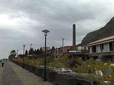 A derelict sugar refinery on the coastal promenade of Jardim do Mar | |
| Official name: Freguesia do Jardim do Mar | |
| Name origin: Portuguese for garden of the sea | |
| Country | |
|---|---|
| Region | |
| Island | Madeira |
| Municipality | Calheta |
| Center | Jardim do Mar |
| - elevation | 50 m (164 ft) |
| - coordinates | 32°44′19″N 17°12′40″W / 32.73861°N 17.21111°WCoordinates: 32°44′19″N 17°12′40″W / 32.73861°N 17.21111°W |
| Lowest point | |
| - elevation | 0 m (0 ft) |
| Area | .74 km2 (0 sq mi) |
| Population | 202 (2011) |
| Density | 273/km2 (707/sq mi) |
| LAU | Junta Freguesia |
| - location | Caminho da Piedade, 13 |
| President Junta | Acácio Fernando Felix de Sousa (PPD-PSD) |
| Timezone | WET (UTC0) |
| - summer (DST) | WEST (UTC+1) |
| Postal Zone | 9370-412 |
| Area Code & Prefix | (+351) 291 XXX XXX |
| Patron Saint | Nossa Senhora do Rosário |
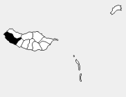 Location of the parish seat of Jardim do Mar in the municipality of Calheta, island of Madeira | |
| Wikimedia Commons: Jardim do Mar | |
Jardim do Mar (Portuguese for garden of the sea) is a civil parish in the western part of the municipality of Calheta in the archipelago of Madeira. The population in 2011 was 204,[1] in an area of 0.74 km².[2] It is approximately 3 kilometres (1.86 mi) northwest of Calheta.
Geography
Jardim do Mar is a sliver of land between the Atlantic Ocean and the cliffs of the neighbouring parish of Prazeres, and accessed by a single roadway and tunnel system to Prazeres and Estreito da Calheta.
The waves break large and surfing is enjoyed here by experienced surfers.
References
This article is issued from Wikipedia - version of the 6/24/2014. The text is available under the Creative Commons Attribution/Share Alike but additional terms may apply for the media files.